The Old Mill on the Tigney River (Historic Site)
Old Mill on the Tigney River - This historic old mill sits next to the Tom Tigney river and Tigney River Trail. It is a picturesque structure throughout all the seasons. The mill was a Carding Mill in its day, used to prepare wool for spinning. It was also used as a Tea Room and artisans market in more recent years. It is a beloved landmark for the residents of Sable River and area.
Tigney River Trail
Tom Tigney Trail
The Tom Tigney Trail is located along the abandoned Halifax and Southwestern railway line. The railway carried passengers and freight between Halifax and Yarmouth from 1907 to 1969. The trail winds through a quiet residential area beside the Tom Tigney River, across the highway several times, and then across the planked and railed former CN rail bridge, ending at Highway 3. From the bridge there is a wonderful view both up and down the Sable River.
The trailhead is located just off Highway 103 beside the East Sable Road. Signage, a picnic table, and hand-painted mural invite the traveler to stop and rest. Other hand-painted murals by local artist and historian Bessie Robart can be viewed along the trail. Trail uses include walking, cycling and motorized ATV use, making it a shared-use trail. This trail links up on both ends with trails developed and maintained by the Woodland Multi-use Trail Association. At the Highway 103 end it links with 8.3 kilometres of trail going to Wilkins Lake and the Queens County line and then to the Broad River Bridge in Port Mouton. The other end of the Tom Tigney Trail at Highway 3 connects to 10 kilometres of trail through marsh and forested areas, and past a lake to Canada Hill Road. This trail is great for birdwatching and observing other wildlife.
A return trip on the trail is about 2 kilometres on a flat graveled surface. A leisurely stroll stopping to enjoy the scenery may take about 40 minutes.
The trail is open year-round but is only maintained seasonally. Respect private property and stay on the trails at all times. Beware of traffic where trails cross roads. Leave nothing behind except your footprints. Pets are welcome but must be on a leash. Please clean up after your pet.
Picnic Park
A great spot to bring a picnic. Enjoy the fresh air and trees.
Footbridge Trail (Swinging Bridge)
Footbridge Trail
The Footbridge trailhead is located on property owned by the Sable River Volunteer Fire Department. The trail, which leads from the parking area to the century-old swinging bridge known as “The Footbridge”, is clearly marked and only accessed on foot. The bridge takes you across the Sable River. It is a strange sensation to feel the bridge moving up and down under your feet. Many photos have been snapped of this unique historic site. Local painter and historian Bessie Robart has painted a beautiful mural to recognize the role the railroad played in Sable River’s past. An interpretive panel at the bridge provides historical information regarding the Mi’kmaq people, who were early residents in Sable River. After leaving the bridge you have the option to follow the Freeman Mill Road to Highway 103, which will take you to the Tom Tigney Trail.
A return trip on the trail is about 2 kilometres on a flat graveled surface and dirt road. A leisurely stroll stopping to enjoy the scenery may take about 40 minutes.
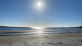
Louis Head Beach & Breakwater
Louis Head’s kilometer long sand beach is located at the mouth of the Sable River. Popular all year round with walkers and runners, it’s long been a place where local residents have gathered for family picnics and swimming during the summer. The beach is constantly changing as sand moves in and out with changing tides and storms, and in very cold winters, ice walls form along the beach providing protection for dunes and vegetation. There are several cottages adjacent to the beach, and with the exception of a small section mid-beach owned by the NS Department of Natural Resources, the land above the mean high water mark is privately owned. Access and a small parking lot are located on Ferry West Road.
Included in the Port Joli Sector of the South Shore IBA, Louis Head beach is designated as critical habitat for endangered Piping Plover. Willets nest in the salt marsh to the west of the beach, and migrating shorebirds feed and rest on the beach during their annual journey south. Ducks, sea birds and Harbour seals feed in the estuary, and Common Loons are resident in the winter. It’s not uncommon to see deer tracks on the beach, or those of raccoons and other small mammals.
Hemeon's Head Conservation Lands (Matthews Lake, Black Point Beach)
Working farmland for many generations, Hemeon’s Head is now an important addition to coastal conservation lands in the MDS. In 2013, the Nova Scotia Nature Trust (NSNT) and Acadia University signed a conservation easement protecting Acadia’s Black Point Beach property and at the same time, NSNT acquired adjacent land extending to Matthew’s Lake. These two properties now comprise the 320-acre Hemeon’s Head Conservation Lands, and are included in the Port Joli Sector of the South Shore Important Bird Area. A wonderful vantage point for watching storm waves, photographers, walkers, clammers, berry pickers and birders enjoy the extraordinary and wild landscape of this beautiful property.
Critical habitat for endangered Piping Plover, the sand and cobble beach extends from the headland looking toward Ram Island to the channel opening into Matthews Lake, where extensive mudflats provide important feeding habitat for migrating shorebirds, including endangered Red Knot. Hemeon’s Head’s bogs, barrens, and forest provide habitat for a wide variety of plants, birds and other wildlife, and in the summer, Ram Island is home to a thriving seabird colony, including Atlantic Puffin, Black Guillemot, and Razorbill. At one time, as many as 11,000 Canada Geese wintered at Matthews Lake!
The Beach Center (Tourist Bureau)
The Crescent Beach Centre
The town also plays host to an architecturally unique facility known locally as " The Beach Centre." It is situated at the gateway to Lockeport, nestled in the dunes on the mainland side of the Crescent Beach. With its stunning view, multitude of activities, and brand new interpretive displays, it is a great place to discover during your time in Lockeport!
It also has bathrooms and showers, as well as an Ice Cream Bar servicing the beach.
The Building is also a C@P (public access computer) site, and the Lockeport Visitor Information Center.
Seaman's Memorial and Marine Annex
Seamans Memorial & Marine Annex - This structure serves as a memorial site for all the brave souls who have lost their lives to the ocean throughout the years. The Marine Annex contains artifacts relating to the important history of fishing in our area, as well as a diorama of what Lockeport's waterfront would have looked like in the early days of the fishing industry.
Crescent Beach & Buchanans Beach
This spectacular 1.5 km sand beach is a focal point for surrounding communities, and was once featured on the Canadian fifty-dollar bill. Walkers and photographers are out on the beach and nearby boardwalk in almost any weather, and in the summer it’s popular for swimming and picnicking. You can see Gull Rock Lighthouse located just offshore from the observation tower at the Crescent Beach Centre, also a perfect vantage point for watching the waves roll in.
Little School House Museum
The Little School Museum in the Town of Lockeport came into being as the Centennial Project of the Lockeport Garden Club. The Club saw an opportunity to make the former school an historic site so that the children of the area might learn more of their past. Through donations from former Lockeport students, the school was purchased by the Garden Club in 1967. Club members undertook to care for the gardens, the Town agreed to mow the lawns and the Ragged Island IODE donated a Nova Scotian flag to be flown during open hours. The Nova Scotia Museum helps with the cost of operation.
The museum is open during the summer months with special visits arranged in the Fall for children from the Elementary School. The building was used as a school from 1845 to about 1880 when it was succeeded by another elementary school structure. The little school then became a dwelling and a front porch and back room were added.
A new building, the marine annex, was added in the mid 1980's to house the Visitor Information Centre. When the Crescent Beach Centre was built, the VIC was relocated to that building. The marine annex building was built with the same architecture as the old school house.
A walking-tour guide book is available at the Little School Museum, which displays artifacts from early settlers.
Seacap's Memorial Park
Seacap's Memorial Park
This large green space occupies an entire block, only meters from the town's shopping district.
This central outdoor performance space often hosts large events throughout the year including Lockeport Rocks, Harmony Bazaar and the annual Mersey Band Concert.
The Lighthouse Stage officially opened during Sea Derby weekend in 2010. A large pavilion provides a covered seating area, which is augmented by the presence of Seaside Play Park a nautically themed playground, that provides hours of entertainment for children of all ages. The play park's features include, a lighthouse slide, a wharf with ladders, tire bridges, a lobster boat and picnic area.
Lockeport Cenotaph Soldiers Monument.
DESCRIPTION OF HISTORIC PLACE
The Lockeport Cenotaph was erected in 1924-1925 of Shelburne granite. It is located at the northwest corner of Hall and Spruce Streets in Lockeport, Nova Scotia. Municipal heritage designation applies to the monument and the corner lot on which it is situated.
HERITAGE VALUE
Early in 1924 Lockeport Town Council began discussions about erecting a Soldiers’ Monument to memorialize the Lockeport men who had been lost during World War I. In May of that year a special meeting of Council was held to accept the report of the committee that had been appointed to examine the feasibility, costs, design and location of such a monument. Those matters being agreed upon, several members of the committee were assigned the task of raising the funds to proceed with the project.
The design for the monument was furnished by Edwin Locke, one of the committee members and a well-known local artist. It was estimated that it would cost twenty-five hundred dollars to carry out the project, fifteen hundred of which had already been raised. The local Women’s Institute was recruited to assist with the raising of funds and three members of the Women’s Institute were appointed to the committee that was undertaking the project.
By October1924 the necessary funds for the project had been raised and the contract to build the monument had been awarded to Mr. C. G. Reed of Shelburne, with the understanding that the contract be completed by July 1, 1925.
The Shelburne Gazette and Coast Guard of Thursday, September 17, 1925 published the following notice: “The Lockeport Soldiers’ Monument will be unveiled on Sunday afternoon next at 2 o’clock. We understand that Rev. Spidell of Liverpool will be chief speaker. Music will be furnished by a massed choir. Col. A. H. Borden will be present. Mr. G. T. MacDonald will lead the music with his cornet.” The same newspaper published a lengthy article the following week describing the unveiling ceremony that had taken place on Sunday, September 20. A final note of summary in the same September 24 issue stated: “Erected in memory of fifteen who did not return from the battlefields of the World War. Monument unveiled by Mrs. George Locke. The monument was designed by Edwin Locke and built of Shelburne granite by Charles G. Reed of Shelburne. The grounds, with two concrete walks, were prepared by Mr. Os (Austin) Peterson. The estimated cost was $2500.”
After later conflicts from which Lockeport men did not return, suitable commemorative plaques with the names of those lost were attached to the monument. The Cenotaph was designated as a municipally registered heritage on February 1, 2001.
Source: Registered heritage property files, "Cenotaph" Town of Lockeport, NS.
Icelandic Settlement Site
Icelandic settlement at Lockeport
The town of Lockeport is situated about 200 kilometers west of Halifax. It was first settled circa 1760-61 by families from the northeastern states of the United States. Among the first to arrive at Ragged Islands, as it was known then were Josiah Churchill and Jonathan Locke, M.D. The town derived its name from the Locke family.
In the 1800s the town flourished with its fishery and West Indian trade. A lighthouse was built at Gull Rock at the entrance to the Harbour in 1853. The town is connected to the mainland by a causeway which runs the length of Crescent Beach. The town now has about 750 residents. Fishing is the main industry.
Trestle Trail
Lockeport Walking Trail (Trestle Trail) - This is a 4km (2.5 mile) walk featuring sections of boardwalk, two old CNR trestle bridges and road. There are views of sand dunes, salt marsh, fishing boats and interpretive signage.
Historic Streetscape (South Street)
The Locke Family Streetscape
Nova Scotia's 1st Provincially Registered Streetscape
Officially registed on June 30, 1988 the Locke Family Streetscape is Nova Scotia's first Provincially Registered Streetscape.
Located in the Town of Lockeport, it includes five historic homes situated at the lower end of South St., overlooking Lockeport Harbour.
It is unique in that all five dwellings are affiliated with the Locke family. Indeed, four of the five dwellings were built for the children of merchant Samuel Locke.
The well preserved homes of the streetscape represent the three historic eras of Nova Scotia's domestic architecture which includes Colonial, Georgian and Victorian.
DESCRIPTION OF HISTORIC PLACE
The Locke Homestead is located on the south side of South Street overlooking Lockeport Harbour to the north, in the town of Lockeport, NS. The Locke Homestead was built around 1876 by Captain Henry Locke, a descendant of Jonathan Locke, one of the original settlers of Lockeport. The homestead also includes a barn. The buildings and property are included in the provincial designation.
HERITAGE VALUE
The Locke Homestead is valued because it is one of five houses forming a family-related streetscape of carefully preserved buildings in Nova Scotia that include a combination of Greek Revival, Colonial Vernacular and in the Locke Homestead, Second Empire style.
Built around 1876 by Captain Henry Locke, a merchant in the West Indies trade, the Locke Homestead is an exceptionally preserved example of domestic architecture from the Victorian era. The only exterior alteration has been the enclosing of the front porch. This house was constructed when the West Indies trade was at its peak and reflects the wealth of that era. The West Indies was a key trading partner for Nova Scotian merchants during the latter part of the nineteenth century.
The preservation of this house as a Locke family dwelling can be attributed, in part, to Churchill Locke. Henry Locke sold his house in 1892 to his first cousin Churchill. Though Churchill was also involved in the West Indies trade, his business expanded into other areas and was therefore able to maintain his stately home during the decline of the West Indies trade. The house has remained in the family since its construction.
The Locke Family Streetscape consists of five houses, all built either for or by the descendents of Samuel Locke. Samuel was a descendant of Jonathan Locke, M.D., one of the original settlers of Locke's Island, and he later renamed Lockeport after him. The houses protected in the Locke Family streetscape all face the harbour, and from west to east are: the Locke Homestead, the William Stalker Homestead, the Jacob Locke Homestead, the Gurden Bill Homestead and the John Locke Homestead.
CHARACTER-DEFINING ELEMENTS
Character-defining elements of the Locke Homestead that relate to its Second Empire style include:
- two-storey, wood construction;
- steeply pitched mansard roof;
- symmetrical three bay facade with large central projecting frontispiece;
- discreetly placed chimneys;
- ornately bracketed eaves and hooded windows.
Character-defining elements of the Locke Homestead that relate to its location within the Locke Family Streetscape include:
- the original barn located at the rear of the property;
- location on South Street facing the harbour;
- location in close proximity to the other four homes within the Locke Family Streetscape.
Rood's Head Park (Chetwynd's Beach, I-spy walking trail)
Roods Head Park
Rood's Head Park is a coastal look off that is perched on the southern most point of the isthmus, that forms the town of Lockeport.
From the top of the hill, a small path winds down to the rocks, providing not only a fantastic view of the breaking surf, but a breathtaking view of the Crescent Beach.
Depending on the time of year, it is also a great place to view Gull Rock, one of our resident Lighthouses.
Features: Walking Trails, Public Recreation Space, Natural Space, Chetwynd's Beach
Lighthouses- Carters Light and Gull Rock
Carter Island is situated about 0.4 mile north of Cranberry Island in the approach to Lockeport Inner Harbour. A light is shown at an elevation of 49 feet from a white circular tower 30 feet high, with two red bands, on Carter Island.
First photograph by photogtapher Hugh Whitaker www.hughwhitaker.com
Gull Rock Lighthouse
Gull Rock, an islet 15 feet high, is situated about 1.2 miles east of Western Head on an extensive bank containing numerous dangers.
Light. - A light is shown from a white rectangular building 44 feet high, sur- mounted by a square tower on Gull Rock. A fog signal of one blast every 30 seconds is sounded from the light structure; the horn points 130ft. A submarine power cable is laid from Gull Rock to the mainland NW. The portion of the lighthouse in front of which the family is standing was removed after automation.
GULL ROCK I - Light Details
- Location: Entrance to Lockeport Harbour, 1.5 miles off
- Standing: This light is no longer standing.
- Operating: This light is no longer operating.
- Began: 1853
- Year Lit: 1853
- Structure Type: Square wood tower, concrete foundation, red lantern
- Light Characteristic: Occulting White (1922)
- Tower Height: 031ft feet high.
- Light Height: 056ft feet above water level.
Jordan River Trail
The Jordan River Trail is located along the abandoned Halifax and Southwestern railway line. The railway carried passengers and freight between Halifax and Yarmouth from 1907-1969. The trail winds through a salt marsh, home to ducks, herons, and other birds. It crosses the Jordan River and ends at the Jordan Branch Road. On a clear day there is a fantastic view from the bridge looking both up the river and out to the ocean. Trees and other plants to look for along the way include speckled alder, wild rose, mountain ash, red maple, birch, tamarack, white pine, and the occasional locust.
The trail head is located at 146 Hayden's Road, a short dirt road loop off Hwy 3 heading towards Lockeport from exit 24 off Hwy 103 at Jordan Falls. A return trip on the trail is just over 5kms on a flat gravelled surface. A leisurely stroll stopping to enjoy the scenery may take about 1.5 hours. The Shelburne County Arts Council has installed a sturdy wind chime of scrap metal by local artist and former blacksmith, Hayward Meisner near the bridge. It has a lovely tone and stands on a tri-pod with a decorative treble cleft on the top.
Widdow's Walk
Located on Crest Street and offering views of Lockeport Harbour and Carter's Island Lighthouse. This structure is the replica of an architectural feature found on many 19th century homes along the coast, called a widow's walk. It was traditionally used as a viewing platform to watch for ships coming home to port, mainly used by the wives of sailors to scan the ocean horizon and hope for the safe return of their loved ones.