Stop 1. Presidio San Agustin del Tucson Museum
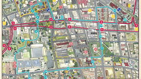
Welcome to the Turquoise Trail!
Stop 1: Presidio Museum
On August 20th, 1775, Lt. Col. Hugo O’Conor, an Irishman serving in the Spanish Army, founded a fort in what is now downtown Tucson. With the exception of a small Spanish chapel across the Santa Cruz River at the foot of “A” Mountain, this was the first European structure in Tucson. By the 1780s, when the 11-acre fort was completed, it consisted of 10-foot-high adobe walls and two corner towers, each 20 feet high. This fort marked the northwestern edge of the Spanish frontier in Arizona. The northeast corner of the original Presidio has been reconstructed and is known as the Presidio Museum.
The Museum also offers docent tours and Living History Days throughout the year. Click on the button below to see the museum's website for more information.
A VIEW FROM THE TRAIL
Look North, up Court Avenue, at the bright yellow building a few blocks up on the left. This is El Charro Cafe. Hit next to learn more about El Charro. Hit next again and follow the turquoise line to continue on the Trail to your next stop.
VIEW FROM THE TRAIL - El Charro Cafe
Established in 1922 by Monica Flin, El Charro Café is the nation’s oldest Mexican restaurant in continuous operation by the same family. Featuring traditional Northern Mexico-Sonoran style and innovative Tucson-style Mexican food, El Charro Café is a local and visitor favorite, known for its carne seca, which is dried on the roof, and other family recipes. The home that the restaurant is located in was the Flin family home, built in 1896 by Monica’s father, a well-known stone mason.
Stop 2. Telles Block
This block is defined by attached Sonoran row-houses, with a large, shady courtyard in the interior. These structures have had a variety of incarnations, including homes during the late 1800s, a lumber yard, a distillery, and a gas station. In addition, the blacksmith shop of the Spanish-era presidio was very likely located here. Now these old adobe buildings house Old Town Artisans (several different artisan shops) as well as LaCo Restaurant.
A VIEW FROM THE TRAIL
As you head toward Stop 3, look to your right to see the Tucson Museum of Art buildings. Walking one block to the west (right, along Alameda) takes you off the Trail to the entrance on Main Avenue. Hit "next" to hear more. Hit "next" again and follow the turquoise line to continue on the Trail to your next stop.
VIEW FROM THE TRAIL - Tucson Museum of Art & Historic Block/Main Avenue
Built in 1973, this art museum features modern, western, and Pre-Columbian art. Five historic homes are on its grounds. The Fish-Stevens Home, the Romero House, and the Casa Córdova, all built in the 1860’s, are classic Sonoran row-houses. In the Casa Córdova an elaborate Nacimiento, a Mexican Nativity Scene, is displayed from November to April. The Mission Revival style Corbett House was built in 1907 by one of Tucson’s first lumber dealers. One block to the north, along Main Avenue are more examples of Territorial period homes. A pocket park, Centennial Park, celebrating the history of this part of Tucson, is located at the southwest corner of Main Ave. and Washington St.
The museum offers a restaurant in the historic Stevens/Duffield House called Cafe a la C'art. In addition to delicious brunches, salads, and sandwiches, the restaurant is well-known for its decadent desserts.
Stop 3. Historic Pima County Courthouse
For over 150 years, Tucson’s Pima County Courthouse was located on this site. This iconic building is the third Pima County Courthouse, built in 1929 and designed by Tucson architect Roy Place. In 2015, it ceased to be a courthouse and is today home to the Southern Arizona Heritage and Visitor’s Center as well as the University of Arizona’s Gem and Mineral Museum.
Immediately in front of the old courthouse is the January 8th Memorial, which commemorates the victims of the 2011 shooting in which six people were killed and 13 others wounded, including U.S. Congresswoman Gabrielle Giffords. The memorial contains significant symbolism celebrating the interests and lives of the victims as well as the strength and resilience of the Tucson community.
Stop 4. Presidio Park Sculptures
Mormon Battalion
This bronze statue commemorates the day in 1846 when Mormon soldiers entered Tucson on their way to California to fight in the Mexican War. The Spanish-speaking citizenry, in spite of being nervous about these armed outsiders, treated the soldiers to a fiesta. One of the Mormon soldiers joined in the fun by playing his fiddle (note fiddle case on north side of statue).
Soldado de Cuera/Leather Jacket Soldier
This Spanish soldier, assigned to the Presidio San Agustín del Tucsón, is dressed for battle with his leather armor (cuera), made of seven layers of deerskin, his rawhide shield (adarga), and a 9-foot-long lance (lanza) made him a formidable adversary. His shield helped to deflect arrows while his long lance was the premier weapon of the day.
Stop 5. Allande Footbridge
Crossing Pennington St., is the Allande footbridge. It is named after Don Pedro de Allande y Saabedra who was appointed one of the first commanders of the Presidio in 1777. Allande personally financed the early construction efforts at the Presidio, which was the largest in the Southwest.
Allande was ruthless in his attacks on the Apache. Allande wrote in a letter to Carlos III, king of Spain that “all of the Apache attacks on this Presidio have been repulsed with heavy losses to the enemy. Lines of countless Apache heads have crowned the palisade” (Desert Documentary, by Kieran McCarty, 1976). As is well known, the Spanish, Mexicans and Americans all attacked the Apache until, in 1886, the surrender of Geronimo ended the so-called “Apache war.”
Stop 6. Pima County Administration Building
Enter the lobby of the Pima County Administration Building via the door with the glass mosaic artwork above it. Inside is an exhibit on the Pimería Alta, detailing the history of our region from prehistoric times to statehood in 1912. This is a great way to get a sense of our own place and time.
Stop 7. Garcés Footbridge and Historic Gazebo Audio
The Garcés Footbridge commemorates Father Francisco Garcés, the Franciscan priest who rode with Lt. Col. Hugo O’Conor in 1775 to found the Presidio in Tucson. He explored throughout the region and died in 1781.
Across the bridge to your left you can see a replica of the original 1880’s gazebo (bandstand). This is the where the stagecoach would gallop into town from Mesilla, New Mexico, along the old Camino Real. For a time, this area became the town square and was a home to the famous El Charro restaurant. Since then many buildings in the area have been constructed and demolished, and a new apartment complex has recently opened.
Stop 8. Flin Building Historic Photos Public Art
Along the walls of the Flin building is a collection of historic photos of Tucson dating back to the 1800s. QR coded information is available on each photo. The Flin is named for Monica Flin, the founder of the well-known local restaurant El Charro, which is still managed by the same family over 100 years later.
Stop 9. Sosa-Carrillo House
This historic house was once owned by the Sosa and Carrillo families. The oldest part of the structure was built in the 1850s. The Sonoran row-house contains an excellent example of a zaguán, a central hall leading from the front to the rear yard designed to create a breeze through the house. The mission fig in the courtyard was probably planted in the 1870s. This cultural center is home to the Mexican American Heritage and History Museum, which is run by Los Descendientes (a local cultural heritage and history organization).
While this site is open to the public, hours may vary. For current hours, go to their Facebook Page: “Mexican American Heritage and History Museum.”
A VIEW FROM THE TRAIL
As you walk along the Tucson Convention Center you will see two signs for Sentinel Peak and Tumamoc Hill. Hit next to learn more. Hit next again and follow the turquoise line to continue on the Trail to your next stop.
VIEW FROM THE TRAIL - Tumamoc Hill & Sentinel Peak/"A" Mountain
Tumamoc means “horned lizard” in the language of the Tohono O’Odham. In an O’Odham legend, a giant horned lizard suddenly began eating people. The O’Odham prayed to their god I’itoi to help them. I’itoi heard them and turned the lizard into a rocky hill. The hill was used by indigenous people for farming and other purposes for several thousand years and is an important archaeological site.Today, Tumamoc Hill is the home of the U of A’s Desert Laboratory founded in 1903. It is the site of the longest continuous botanical monitoring plots in the Sonoran Desert. Tumamoc is also a very popular walking route for seekers of aerobic exercise. The Tumamoc Tour app is available on smartphones for those interested in learning more about the desert plants and animals around them as well as the area’s 4,000+ years of human history.
To the west you can see a basaltic peak adorned with the letter “A.” This was once a lookout for Spanish and Native American sentinels, who watched for raiders approaching the Presidio as well as the mission that was located at the base of the mountain. The Tohono O’Odham called their settlement at the base of the mountain “Chuk Shon,” which means “at the black base.” This is the source of the name Tucson. The “A” was added in 1915 in a burst of University of Arizona student enthusiasm, as the result of a football victory over Pomona College. A member of the team and a civil engineering student suggested to their professor that the class should survey the mountain for a good location for an “A” for Arizona. Students worked weekends to clear the site, dig the outline of the letter and haul the mortar/water mixture up the mountain.
The Tucson Fire Headquarters and Tucson Fire Department History Museum.is located across the street in front of you in the historic Barrio Viejo neighborhood. While modern, the building and site were designed to be a good neighbor to the Barrio, respecting local culture and tradition. A formal Placita was designed in the front, like a traditional Mexican plaza and there is a memorial to the homes lost during 1960's urban renewal as well as several sculptures.
Stop 10. El Tiradito (The Castaway)
This shrine is typical of small shrines in many communities in Mexico, where people come to burn candles and pray, asking for help with their problems. One legend associated with this shrine involves a tragic love triangle in the 1870s, with a husband killing his wife’s lover. A priest would not let the man be buried in the consecrated cemetery so local people lit candles at this location to pray for his soul.
Stop 11. La Pilita Patio and Carrillo Gardens
Enter the courtyard to read about Carrillo Gardens, Elysian Grove and the Simpson baths which were located just west of this site.
Early settlement of Barrio Viejo was based largely on the area’s proximity to El Ojito or “Little Eye Spring,” a natural perennial spring that was located at Main Avenue and Simpson Street. First developed as a bathhouse in 1880, it was later developed by Leopoldo Carrillo who constructed Tucson’s first public park, Carrillo Gardens, in the 1850's. It was an eight-acre garden and was landscaped with peach, quince, pomegranate and apricot trees, as well as grape vines. It had “lakes,” which were actually ponds over the natural springs. A mule-drawn wagon “bus” would bring visitors to the gardens which were six blocks from downtown. The cost for the ride was a nickel. Carrillo later sold the park to the Drachman family and it was renamed Elysian Grove. In 1930 the site became the location for Carrillo Elementary School.
A VIEW FROM THE TRAIL
Further down Main Street you will see Carrillo School on the right. Hit next to learn more. Hit next again and follow the turquoise line to continue on the Trail to your next stop.
VIEW FROM THE TRAIL - Carrillo Elementary School
To the south across Simpson St. stands this red-tile-roofed elementary school. Built in 1930 in the Mission Revival style, it was named for Mexican businessman Leopoldo Carrillo, the developer of Carrillo Gardens, which were located near La Pilita Patio and El Tiradito Shrine. The school is well known for its traditional Christmas presentation, Las Posadas, a parade of students re-enacting the time Mary and Joseph were searching for a place for Mary to give birth to Jesus.
Stop 12. Cuauhtémoc Statue
Regarded as the first resistance fighter in the Americas and the last Aztec Emperor, Cuauhtémoc is revered in Mexican culture. Created by artist Luis Mena, the statue captures the perseverance and spirit of the people who established and once lived in what is now known as Barrio Viejo.
Stop 13. Teatro Carmen
Carmen Soto Vasquez was the wife of the builder of Teatro Carmen, and the building is named for her. Opened in 1915, it started as a theater devoted to staging dramatic works in Spanish. It then became a movie theater, boxing arena, garage, and Elks Lodge. Today, the building is undergoing renovations and will soon be a theater again.
Stop 14. The Ferrin House
This old adobe home was built in the 1860s by tailor Joseph Ferrin and his wife Therese. Therese and her daughter Clara were instrumental in building the first synagogue in Arizona a few blocks to the south on Stone Ave. A store was added to the residence in the 1880s. For many years it was owned by the Rollings family who ran it as the Cushing Street Bar and Restaurant. The structure now houses The Coronet Restaurant.
Stop 15. Barrio Viejo Streetscape
On the front of No. 124, note the decorated canales, long metal spouts that direct rainwater away from the adobe walls.This area of Tucson grew in population in the late 1800s and early 1900s and became very ethnically diverse. It included residents of Mexican, Chinese, Jewish, African-American and a variety of European backgrounds. Most of the Chinese immigrants came to work on the railroad in 1880 and then ventured into farming and running small grocery stores.
A VIEW FROM THE TRAIL
At the corner of 14th Street and Stone Avenue, look left to see the Saint Augustine Cathedral. Two blocks down Stone on the right is the Jewish History Museum and Holocaust History Center. Hit next to learn more about the Cathedral. Hit next again to learn about the Jewish History Museum. Hit next one more time, and follow the turquoise line to continue on the Trail to your next stop.
VIEW FROM THE TRAIL - St. Augustine Cathedral
On your left you can catch a glimpse of St. Augustine Cathedral. Begun in 1896, this Spanish Colonial Revival architecture features a magnificent sandstone facade that has an unusual tribute to local flora and fauna featuring a saguaro, yucca, horned lizard and various cacti. Housed inside, near the north wall, is one of the original bells from the Spanish-era Presidio San Agustín del Tucson (Stop #1 on the Trail.) Note that this “St. Augustine” is spelled with an additional “u” and an “e” at the end unlike the original St. Agustín for which the Presidio was named. “Augustine” is the English spelling of “Agustín.”
VIEW FROM THE TRAIL: Jewish History Museum/Holocaust History Center
Down Stone, on your right is the first Jewish synagogue building in Arizona, built in 1910, has been restored and is the home of the Jewish History Museum. It houses displays that tell the stories of the American Jewish experience in Southern Arizona and the West.
Stop 16. Temple of Music And Art
This 1927 theater, constructed on behalf of The Saturday Morning Music Club, brought a flourishing musical scene to Tucson including world famous artists such as Jascha Heifetz. Built in the Spanish Colonial Revival style, this building features an inviting courtyard with a fountain. The building was restored in 1990 and is a popular theater venue, renowned for its excellent acoustics. It is the home of the Arizona Theatre Company.
A VIEW FROM THE TRAIL
As you turn right on 13th Street, look up Scott Avenue to see (G) The Blenman House Inn. Hit next to learn more. Hit next again and follow the turquoise line to continue on the Trail to your next stop.
VIEW FROM THE TRAIL - Blenman House Inn
On the west side of Scott St. is the historic Bring Funeral Home which opened in 1928. Today the building houses a bar and office space. Beyond it is The Blenman House Inn. Built in 1878 as a private residence by Charles Rivers Drake, a former US Army officer, the Blenman House is thought to be the only example of a Victorian-style building made of mud-adobe. It was purchased in 1891 by Judge Charles Blenman and stayed in the family for over 100 years. The flagpole in the front yard is the original and was erected by Blenman. Today, the home is a popular bed and breakfast.
Stop 17. Armory Park
During and immediately after the Civil War this area was the camp where soldiers were temporarily housed. In 1873, the camp was moved out of town to its ultimate location on Craycroft Road because the civilian neighbors considered the soldiers’ behavior excessively rowdy. The camp was then renamed Fort Lowell. Four monuments are located in Armory Park honoring those who fought in the Spanish-American War, WWI, WWII, and with the Mormon Battalion in 1846. There are also two plaques, one showing soldiers and their families at Camp Lowell, and one showing the armory building for which the park was named.
VIEW FROM THE TRAIL - Former Carnegie Library/Children's Museum Tucson
Built in 1900 as the Carnegie Library, this building has survived fire and the loss of much of its ornamentation. The massive bench at the front was designed by California architect Bernard Maybeck and sculpted by world-famous sculptor Benjamin Bufano in honor of Arizona’s pioneer settlers. Today, the building is home to the Children’s Museum Tucson, which offers many opportunities for educational play for children.
Stop 18. Independent Order of Odd Fellows
The Odd Fellows have been an active social club since 1891 in Tucson as well as a charitable group whose goals include helping fellow community members in times of need. This early 20th century commercial building once housed the local group of the International Order of Odd Fellows, as well as their spacious dance hall on the second floor. You can still see the letters “IOOF” just below the roof. The building now houses The Delta Bar & Grill on the first floor.
Stop 19. Johnny Gibson's Downtown Market
This market opened in 2015, the first market to open in the downtown for many years. Starting at least as early as 1882, a wide variety of businesses have been located here including a car company, a furniture store, the City Market in 1932 that became the Market Center in 1937, an auto supply store, the Rose Tree Snack Bar and, in 1987, Johnny Gibson’s Gym Equipment. Gibson was a nationally known bodybuilder who won the title of Mr. Arizona in 1950. For over 50 years, he was also a much-loved local barber.
Stop 20. Hotel Congress
Built in 1919 across from the railroad depot, this hotel was popular with train travelers. It became famous in 1934 when members of John Dillinger’s gang rented rooms. While they were there, the building caught fire and the gang paid some firemen to carry their bags outside. The firemen didn’t open the bags but wondered why they were so heavy; the bags contained submachine guns and bulletproof vests. The gang was recognized from a True Detective Mysteries magazine and soon arrested. In addition to its infamous history, the hotel has a beautiful lobby and is home to The Cup, a popular downtown restaurant. It also hosts an active night spot called Club Congress.
Stop 21. Historic Railroad Depot
On your left is the triangular-shaped MacArthur Building. Built in 1908 it was originally the Heidel Hotel and served passengers from the railroad. It is now used as an office building.
On your right is the Historic Railroad Depot built in 1907. It was restored in 2004 to its 1942 appearance. In addition to a functioning passenger train lobby, it houses an Amtrak office, Maynard’s Market deli and restaurant and the Southern Arizona Transportation Museum, a museum highlighting the history of transportation in the region. Historic steam locomotive #1673 is located trackside. A life-size sculpture of Wyatt Earp and “Doc” Holliday marks the 1882 incident ending with the death of Frank Stilwell near the first depot (now near the locomotive). There is also a small memorial for the DEA agent killed in 2021 during a train inspection.
A VIEW FROM THE TRAIL
Follow the Trail to Stone Avenue and look North to see the Pioneer Building. Hit next to learn more. Hit next again and follow the turquoise line to continue on the Trail to your next stop.
VIEW FROM THE TRAIL - Pioneer Hotel Building
Opened in 1929 in the center of downtown Tucson, the Pioneer Hotel (on Stone Avenue) catered to the social elite like Harold and Margaret Steinfeld. Owners of a large downtown department store called Steinfeld’s, they lived in a penthouse in the hotel. A disastrous fire severely damaged the building in December 1970, and the Steinfelds were among the 29 victims. The fire, in combination with new Tucson suburbs, hastened the decline of downtown Tucson. Today Tucson’s downtown is enjoying a revival with the help of the Rio Nuevo Multipurpose District and the Business Improvement District, which partially funds the Downtown Tucson Partnership.
Stop 22. Fox Tucson Theatre
After being closed for 30 years, this grand Art Deco movie theater has been restored to its former greatness reopening in 2006. Originally designed for vaudeville and silent movies, it became Tucson’s pre-eminent movie theater. It was the site of the world premiere in 1940 of the film “Arizona” starring William Holden and Jean Arthur. It now hosts both screen and stage events.
This is the last stop on the Turquoise Trail! To return to your starting point, follow the painted trail back to the Presidio Museum, stop #1.