Introduction
Text for this tour has been kindly provided by Auckland Council.
The original shoreline in Auckland has been changed dramatically by reclamation works in the 19th to early 20th centuries, the development of rail connections, and the construction of the Harbour Bridge and motorway in 1950s and 60s. The marinas and commercial wharves, which now stretch from Westhaven through to Judge’s Bay, are very different from the foreshore sighted by the first settlers to Auckland.
The alteration of Auckland’s shoreline after 1840 until present day; from sandy beaches, rocky cliffs and mudflats – to modern wharves for passengers and container traffic illustrates the change from colonial port to modern city. In tracing the line of the original foreshore we can see the history of the development of Auckland.
Pt Erin - Okā
Park at the Pt Erin baths. Walk to the left of the complex then turn right down the cliff. This grass area was reclaimed for the bridge approach in the 1950s. Walk to the right under the viaduct. The undulating shore line is marked by many of the old pohutakawas on the cliff.
Okā is an ancient pā (fortified village) also called Te Koraenga (‘theheadland). Together with Te Onewa pā across the Waitemata- River, Okā provided a base for summer fishing in the famed shark fishing grounds in the upper Waitemata harbour. The legendary taniwha and guardian of the Hauraki people, Ureia, roamed the gulf and frequented Pt Erin to scratch his back against the cliff and reef.
The reason for the name ‘Erin’ is unknown – Erin is another name for Ireland. In this vicinity were the Shelly Beach salt water baths and small boatyards, all of which have disappeared as a result ofthe reclamation for the Harbour Bridge and motorway.
St Mary's Bay - Ko Takere Haere (Western End)
Walk up St. Mary’s Bay Road, turn left onto London St. Here aresome the old grand houses of St Mary’s Bay. Turn right up New Street and then left on Waitemata St. At the end turn left down a lane to Jacob’s ladder. These are steep steps.
Alternatively continue up New St. which runs through land granted to Roman Catholic Bishop Pompallier in the 1850s. On the left is St Mary’s school and convent and on the right the Bishop’s Palace. Left down College Hill Road to the corner of Beaumont St.
The former beach at St Mary's Bay was known as Ko Takere Haere or 'the split canoe hull'. The name commemorates an event where slaves who were hauling a waka onto shore accidentally caused it to slip on its skids cracking the hull. This was taken as a bad omen and the slaves were thus sacrificed for their indiscretion.
The hinterland of this bay was named Mount St Mary by Bishop Pompallier, who purchased it for the Catholic Church in 1853. St Mary's Bay was the major 'hauling out' area for boats moored on the western side of the city, and the home of the Ponsonby Cruising Club. A 1956 campaign by local residents who fought to keep the area tidal was defeated and St Mary's Bay was sacrificed to form the Harbour Bridge approaches.
St Mary's Bay (Eastern End)
A lane at the bottom of Jacob’s Ladder leads to Beaumont St. Turn right. The Auckland Gas Company’s 1904 brick buildings have been converted into shops and offices. At the corner, cross to the left. Under the viaduct is the Campbell’s Free Kindergarten. Continue by the park or cross and walk through the Victoria Park Market.
Te Papaku a Whai or 'Whai's Shoal' is the Māori name for this area. The identity of Whai however has since been lost. This area lay beyond the city's western boundary (Franklin Road) and constituted the eastern end of the St Mary's Bay foreshore. An 1857 British Admiralty map shows New Street reaching down to the shoreline. St Mary's school for Maori Boys and a Seminary were built at the end of Waitemata Street on the point which divided Freeman's and St Mary's Bays. This point too was lost in the reclamation process.
Pt Fisher - Acheron Pt - Te Tō
A headland pa-called Te Tō ('To haul up a waka') once occupied the eastern headland of Freeman's Bay above Beaumont Street. Te Tō was another of the many satellite fishing stations dotted along the inner Waitemata harbour. Te Tō and its strategic importance is still recited in speeches by Māori on marae in the Auckland today. The first European name of the point was Pt Fisher (after Acting Attorney General and Land Commissioner, Francis Fisher). It was later known as Acheron Point, after H.M.S. Acheron, a survey vessel which charted Auckland's Waitemata coastline between 1848 and 1851.
Freemans Bay - Waiatarau (Western End)
A lane at the bottom of Jacob's Ladder leads to Beaumont St. turn right. The Auckland Gas Company's 1904 brick buildings have been converted into shops and offices. At the corner cross to the left. Under the viaduct is the Campbell's Free Kindergarten. Continue by the park or cross and walk through the Victoria Park Market.
'The Reflecting Waters' is the Māori name for what was once a glistening bay but is now Victoria Park. A freshwater stream called Waikuta ('Waters of the reed') once discharged into Waiatarau at about the foot of College Hill while the Tunamau ('to catch eels') stream spilled into the bay at about Franklin Road. Both names indicate the abundant natural resources once found here. The origin of 'Freeman's' is disputed - it either referred to one of Governor Hobson's officials, James Stuart Freeman, or free settlers.
Freemans Bay - Waiatarau (Eastern End)
On the old shoreline in this vicinity were numerous sawyers, boatbuilders and hotels, which disappeared during the western reclamation project carried out by the Auckland Harbour Board in the 1880s. A more modern Maori name for the area was 'Waipiro' or 'stinking water', mocking the early drunken residents. The 'Birdcage' (formerly Rob Roy Hotel) and Freeman's Hotels both remain. Freeman's Hotel dates from 1886, but there has been a hotel on this site since around 1860.
Freemans Bay - Waiatarau (Drake Street)
Te Koranga ('the scaffolds') is the Māori name for this area. Fish and shark would be hung and dried on scaffolds and processed over the summer months before being transported to base camps such as at Maungakiekie for the leaner winter months. The present day Drake Street runs along the former cliff line. Once this street was the western termination of Victoria Street. Drake Street was the mail centre for Freeman's Bay - there was a twice daily collection from Slatterly's greengrocery. This waterfront area is redolent of the English navy. Streets here are named after Sir Francis Drake, Admirals Blake, Fanshawe, Halsey and Pakenham.
Freemans Bay - Waikokota
Another name for the bay was Wai Kokota or 'the place where cockles could be harvested'. This area forms the eastern end of Freemans Bay basin. At the foot of Wellesley Street West are the brick buildings and chimney of the Auckland City Destructor, built in 1905, and since converted to form the Victoria Park Markets. Parts of the original cliff line, and a large coastal pohutakawa tree, survive in the market complex.
Franshawe Street - Te Pane Iriiri
Cross the street to Halsey St. The building of Millar Patterson 1903 still serves its original purpose as marine engineers and foundry. Turn right at Fanshawe Street. This road is on the old beach with the cliffs still to be seen. Cross Nelson St.
The Māori name for the land surrounding the junction of Halsey and Fanshawe streets is Te Paneiriiri, 'the head hung up'. It apparently was the scene of a victory ceremony performed by the Ngati Poua. Two large timber companies (Leyland O'Brien and the Kauri Timber Company) were located on the seaward side of Fanshawe Street. Tiny Dock Street, which had its own wharf, was situated between Hardinge Street and the eastern Freeman's Bay shoreline. The wharf was a casualty of the reclamation. At the end of WW2, Māori were encouraged to move to the city from rural areas. A converted war depot building on the corner of Halsey and Fanshawe Streets became the 'Māori Community Centre' substituting as a marae and gathering place for the newly arrived Māori. Most famous were the dances and showbands that played there including such greats as Prince Tui Teka and Billy T James. Today the site is owned by local tribe Ngāti Whātua.
Brickfield Bay
This tiny bay was situated below Hardinge Street at the foot of Wyndham Street, and was a mere indentation of the much larger Freeman's Bay. It marks the site of one of Auckland's earliest industries, brick making. At the foot of Nelson Street was a small wharf, where fishermen landed their catch. The Māori name is Te Hika a Rama. Rama lit a fire here to warm his grandchild. This was in a time of conflict and the fire inadvertently alerted his Ngāti Whātua enemies across the harbour to his whereabouts whereupon he was attacked and killed.
Smale Point - Pt Stanley - Ngauwera
Smale's Point separated Freeman's Bay from Commercial Bay, which was centred at the foot of Queen Street. In 1840 the point was named after Captain Owen Stanley, of H.M.S. Britomart. Shortly afterwards, a Captain David Smale bought a property on the point ('hauling goods up by windlass') and the area became known as Smale's Point, until it was cut down in the 1880's to allow Albert Street to extend into the wharf area. A pā once stood on the old cliff line near the Customhouse corner of Albert Street and Customs Street East. 'Nga u wera' means 'the burnt breasts' though the origin of the name is not now known. Point Stanley was near the bottom of Hobson St. Crossing over Hobson Street look at one of the oldest business still in existence – the ship chandlers Fosters built in 1906.
Swanson Street
Cross Albert St and pass the magnificent Customs House built in 1888. It has been restored and houses duty free shops. Turn right on Queen St.
The high land here defines the inner limits of Commercial or Store Bay, the first area of European settlement in 1840. Until 1883 Swanson Street was known as West Queen Street. A Māori track, Te Tarapounamu, led up Swanson Street to a pā on the ridge, possibly Nga Wharau Tako. Mills Lane was named after Thornton, Smith and Firth's flour mill nearby. Josiah Clifton Firth (1826-1897) became a prominent businessman and landowner.
Lower Queen Street
This portion of Queen Street is built on the first land to be reclaimed from the sea, in 1859. Fort Street (originally 'Fore' Street) marks the original shoreline and the centre of Commercial Bay, which was chosen as the commercial hub of the new capital by Surveyor-General Felton Matthew, in 1841, and has remained so today. Nearby Shortland Crescent was the first 'main' street in Auckland.
Fort/Gore Streets
Turn left into Shortland Street, and left into Jean Batten Place to Fort St. (Jean Batten was a New Zealand aviatrix), right onto Fort St. This area was the centre of the merchant commerce where importers and exporters built wharehouses close to the wharves and the railway line. Many of these buildings are being refurbished. At the curve of Fort St is the white facade of the Northern Roller Mills once a landmark on the Auckland skyline.
Fort Street led along the original shoreline. There were steps up the hill to the Britomart Barracks. The Māori name for this area is Te One Panea, 'beach of the heads in line'. It is said the heads of slain enemies were stuck on posts from one end to the other of the foreshore.
Britomart Place
This is a comparatively recent place name, given to the street to the east of the Britomart transport terminal. The name was taken from the demolished Point Britomart. H.M.S. Britomart was a British brig which visited Auckland in the 1840's. Nearby was the Metropolitan Church of St Paul (Anglican) at Emily Place. St Pauls was known as the 'soldier's church' as it was attended by the regiments at nearby Fort Britomart and the Albert Barracks (Albert Park).
Point Britomart
This site marks the end of Point Britomart, a headland which was known firstly as Flagstaff Hill, and then shortly afterwards, Pt. Britomart. Auckland's first European fort was established on the point on the site of an old pā, Te Rerenga-oraiti ('the leap of the survivors') in 1840. The ancient name describes two similar incidents when attacking Ngāti Whātua forces drove their foe off the end of the headland with only few surviving the leap into the Waitemata harbour below. The headland was demolished in the 1880's and used as fill in nearby Official Bay.
Offical Bay - Wynyard Pier
Te Hororoa ('the slipping away') is a place in Official Bay. Prior to the 17th century invasion of Ngāti Whātua part of the pā here slipped into the sea with a number of people perishing. This was taken as a bad omen foretelling the invasion from the north-west.
Official Bay (locally known as Exclusion Bay) was named after the government officials who resided here. These officials were members of Hobson's Crown Colony government, established in Auckland in 1840. Wynyard Pier, a timber wharf, was erected in 1851, funded largely by private subscription. It was named after Colonel Robert H Wynyard who settled in the bay in Felton Mathew's old home.
Mechanics Bay - Te Toangaroa
Te Toangaroa ('the dragging of waka a long distance') is the Māori name for the old bay here. The tide went out along way so if one missed the high tide it lead to an arduous and unwanted task to haul waka to the beach at present-day Beach Road. This site marks the location of the dwellings of the first 'mechanics' or workmen who were employed by the government to build the first houses in the new capital. Here also were Auckland's first sawmills, boatyards, and a rope walk. Gradual reclamation, completed as late as the 1920s, provided the site for the Railway Station and container wharves.
Constitution Hill - Te Reuroa
Continue along Beach Road. The 1930s Railway Station has recently been converted to student accommodation.
Auckland's first Parliament Buildings were located just over the brow of this hill, on land behind the extensions to the High Court. The hill is reached by an access way from the old shoreline below, and is flanked by Alten Road. Te Reuroa pā, 'the longer outer palisading' stood on the Supreme Court site, and also extended to the foreshore. On Beach Road at the foot of Constitution Hill was a Maori Reserve. A Māori hostel built by Ngāti Whātua was established here to house Māori traders who arrived from all over New Zealand. In 1848 Māori delivered 20,000 tons of potatoes, apples, peaches and wheat at this place.
Augustus Terrace
Walk up Parnell Road and cross to Augustus Terrace.
This area, at the eastern end of the original Mechanic's Bay, overlooked a tidal inlet where boatbuilding was carried on. The Waipapa, a tidal creek meaning 'the waters of the flats', flowed down from the Parnell ridge. Augustus Terrace, formerly Selwyn Terrace, was named after Bishop George Augustus Selwyn.
The Strand
At the end take the walkway down the cliff beside the Dilworth Apartments. Turn right on The Strand.
This marks the original beachline. Pt Dunlop was the landward extremity, named after a British Naval Commander, Robert Dunlop, of H.M.S. Favorite. It was later renamed Barnabas Point, after St Barnabas Church which once stood here but was moved to Mt Eden. The point was cut back in the 1870s.
St Georges Bay - Te Wai O Taikehu
Taikehu is the ancestor for the ancient Ngai Tai tribe. Taikehu arrived from the pacific islands aboard the famed Tainui waka and named a number of places in the Auckland region including Nga Tuaira a Taikehu ('the dorsal fins of Taikehu') being the 3 peaks of Rangitoto.
This was originally known as Cooper's Bay, after the first Colonial Treasurer, George Cooper, then George's Bay, and finally St George's Bay. St George's Bay Road led down to the shoreline where remnants of the early cliff survive. The Māori name for the area is Waiataikehu or waiakehu, 'waters of Taikehu'. St George's Bay was cut off from the sea in 1920 and then reclaimed.
Campbell's Point
If it is open, take a peak into the Saatchi & Saatchi Building to see the innovative re-use of a warehouse. Continue on the Strand, crossing St George's Bay Road and turn right Gladstone Road.
From the Fred Ambler Lookout, walk up to Dove Myer Robinson Park. Here the trees recreate a scene that may have been seen by early Auckland citizens.
This Point was named after John Logan Campbell (1817-1912) sometimes known as the 'Father of Auckland'. He was one of the first settlers to purchase land in Auckland, and was Mayor of the City and a local Member of Parliament. His handsome house Kilbryde stood on the Point but was demolished in 1924. The Point itself was cut down in 1929, enabling the waterfront road to proceed and Gladstone Road to curve around directly into the Strand.
Judge's Bay
Down to the little beach at Judge's Bay.
In 1841 Judge Martin and Attorney General Swainson arrived in Auckland with houses in prefabricated sections. Swainson built on the west side and the Martins on the east of this bay. The little chapel of St. Stephen's built in 1857 is all that remains of this time. Known as Taurarua 'the two ropes' it is thought that this name referred to the two administrators of British justice. Judges Bay in 1915 looking towards Campbell's Point with the first Parnell Baths in the foreground.
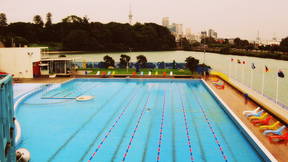
Parnell Baths
Continue around the foreshore to Parnell Baths and over the walking bridge. From this vantage point the original shoreline of Orakei Basin – Hobson Bay can be seen.
The first salt water baths were built on the site in Judge's Bay in 1914 by Auckland City Council. Modifications and improvements were made from that time until the 1940s. Major redevelopment of the Baths was undertaken in the 1950s, to create a Lido atmosphere - a glamorous seafront bathing resort. The design by the Auckland City Council's Architects Office was awarded a gold medal by the New Zealand Institute of Architects in 1958. The glass mosaic murals were designed by artist James Turkington, in collaboration with the architects.
To return to Pt. Erin take Bus No 757 or 769 on Tamaki Drive to the Britomart Transport Centre. Then take Bus 005 at Customs St. West, stop D20, to Jervois Road, and walk down Curran St. Information at at.govt.nz.