Beaches and Beacons Preview

Access this tour for free

Experience this tour for free. Available through our app.

Download or access the app

iOS Android Web
1

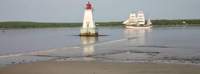
Charlesville Lighthouse

The original Charlesville (Pubnico Harbour) Lighthouse was built in 1854. It was a white, square, pyramidal wooden tower with a red lantern, and a dwelling attached. Both were demolished in 1967 and replaced with a conical fibreglass tower. Accessible on land. Great spot for viewing the Pubnico Wind Farms and fishing boats in Pubnico Harbour.

2

Woods Harbour Lighthouse

Builton a rock ledge of Cockawit Passage, the wooden lighthouse was built in 1900. It was replaced in 1965 and then de-staffed in 1993.

3

Stoddard Island/Emerald Isle Lighthouse

Emerald Isle, Shag HarbourLocated in Shag Harbour, this square, wooden tower was built in 1877.Standing at 21 feet tall the station was de-staffed in 1993.

4

Bon Portage Island Lighthouse

Shag HarbourThe Bon Portage Island lighthouse was established in 1874. For 110 years, 16 principal lightkeepers and their families kept the light burning on this small, windswept island. The longest serving keeper was Morrill Richardson, who along with his wife Evelyn, bought the island (except for the lighthouse property) in 1929. In 1945, Evelyn Richardson's classic book “We Keep A Light” was published and quickly became a best-seller in Canada. She described her family's life on the island with sensitivity and humour, noting both the disadvantages and joys of life on an isolated island. Bon Portage Lighthouse was replaced in 1964 by the current building. Accessible only by boat. - source

5

West Head Lighthouse

West Head, Clark’s Harbour B0W 1P0Established in 1888, this lighthouse was built on the west side of Cape Sable Island. Replaced in the 1970's this 51 foot tower can be seen from afar. It was automated in 1993.

6

Cape Sable Island Lighthouse

BarringtonLocated on the southernmost tip of Atlantic Canada, the Cape Sable Lighthouse, originally built in 1861, is the tallest lighthouse in the Maritimes at 101 feet. The station was de-staffed in 1986. It is only accessible by boat, but there is a magnificent view from the beach at the end of The Hawk Road, located on Cape Sable Island.The lighthouse is not open to the public,but visitors can explore the exterior and surrounding area. This area is also designated as an Important Bird Area. On July 28, 1989, the Federal Heritage Building Review Office designated the Cape Sable Light tower a Classified Building, thereby ensuring it the highest level of ongoing protection.

7

The Hawk

The Hawk BeachThe Hawk Beach has been scoured by the ocean for thousands of years, exposing a unique drowned forest, believed to be 1500 years old. In the distance The Cape Light, the Tallest lighthouse in Nova Scotia, stands guard.Come and explore the mysterious wonder on Nova Scotia's sothernmost tip, Cape Sable Island. Eastern Cape Sable Islandis an Important Bird Area. ibacanada.ca/site.jsp?siteID=NS016Facilities: Port-a-Potty during summer monthsActivities: Walking,Photography,Birding, PicnickingParking: RoadsideAccess: Path

8

Daniel's Head Beach

589 Daniel's Head Road, Cape Sable Island B0W 1P0The beautiful 2.5 km long Daniel’s Head Beach (locally known as South Side) is one of the most popular beaches on Cape Sable Island for walkers and photographers throughout the year. Migrating shore birds can be found feeding in the late summer and fall. Snowy Owls and Brant geese are common winter visitors as is the occasional nor’easter, making this a dramatic spot for watching the surf roll in. Eastern Cape Sable Island Important Bird Area ibacanada.ca/site.jsp?siteID=NS016Facilities: Change Rooms, Outdoor Toilet, Pinic Area availavle during Summer MonthsActivities: Walking,Photography, Birding, Picnicking,SwimmingParking: Parking LotAccess: Boardwalk

9

Stoney Island Beach

Nearly 2km of white sand and rolling dunes make Stoney Island a favorite with the local residents for swimming and picnicking during the summer. With its eastern exposure, it's a perfect beach for for taking an early morning walk and watching the sunrise. Nearby Bakers Flat provides habitat for migrating waterfowl during the spring and fall, ia a popular destination for birders and photographers.Facilities: NoneActivities: Walking, Photography, Birding, Picnicking, SwimmingParking: RoadsideAccess: Dirt pathEastern Cape Sable Island Important Bird Area ibacanada.ca/site.jsp?siteID=NS016

10

North East Point Beach

McGray Avenue, Cape Sable Island B0W 1E0Just across the Cape Sable Island Causeway from Barrington Passage, NorthEast Point Beach is a local favourite for swimming, soaking up the sun, or catching a weekend boat race. You might see a dory row by, or even catch a ride in one. The causeway was completed in 1949 and replaced a coastal ferry service linking North East Point with the mainland.

11

Seal Island Light Museum

The museum, a replica of the top half of the Seal Island Lighthouse. It displays lighthouse equipment and memorabilia,and tells the fascating history of the lighthouse and the area's light keeping families on Cape sable Island, Bon Portage and Seal Island as well as the hundreds of shipwrecks that made the waters surrounding Seal Island a graveyard in the days of wooden sailing ships. From the third level, you can climb the iron stairs as the keepers did for 76 years and see the orginal clockwork mechanism and the only installed Fresnel lens in Nova Scotia. From the top, you can take in the spectacular view of Barrington Bay. Season is from June- September

12

Sandhills Day Use Provincial Park

28 Sandhills Beach Road, BarringtonSandhills white sand beach is backed by an ever-shifting dune system. Its wide sand flats warm at low tide making it a great place for swimming and snorkeling. Migrating shorebirds feed on the tidal flats, especially during late summer and fall. Bring the family for the day, and pack a lunch to enjoy in the large picnic area. Barrinton Bay is an Important Bird Area ibacana.ca/site.jsp?siteID=NS018Facilities: Change Houses, Pinic Area,Playing Field,Outdoor Toilets,Shower & Water available when park is openActivities: Walking, Photography, Birding, Picnicking,Swimming,KayakingParking: Parking lotAccess: Groomed Path, Boardwalk, Stairs

13

Crow Neck Beach

Baccaro Road, BaccaroThe wild forces of the wind, tide and occasional storm constantly reshape this nearly 2 km long beach, a treasure for birders, walkers and photographers. The 45 foot high Baccaro Lighthouse is just minutes away, has an area for picnicking, and the view is breathtaking. Baccaro (from the Basque word bacalao meaning codfish) is the oldest place name in Nova Scotia and is the southernmost point of mainland Nova Scotia. South Shoe Important Bird Area ibacanada.ca/site.jsp?siteID=NS017Facilities: NoneActivities: Walking, Photography,BirdingParking: Limited RoadsideAccess: Groomed Path and Steep Cobble

14

Baccaro Point B0W 1E0

Perched on the edge of the ocean, this lighthouse is an important bird watching site. Located on the east side of Barrington Bay near Port La Tour, this small wooden lighthouse was built in 1934. It replaced the original building that was built in 1850, which was destroyed by fire. Baccaro is the oldest place name in Nova Scotia. It comes from the Basque word "bacolao", which means codfish. Baccaro point is the southernmost point of mainland Nova Scotia. (Cape Sable, on Cape Sable Island, is the furthest south.) In 1852, the materials for the first lighthouse were hauled along the beach, since there was no road leading to it. Today, the 45-foot tall, square, tapered building stands fast on its bed of solid rock. Accessible by land. - source

15

The Salvages Lighthouse

Cape NegroThe Salvages is a group of ledges and rocks on the west side of Cape Negro Harbour. In 1915, a diaphone was placed on the highest rock, which gave three blasts every minute to warn seafarers. In 1965 a 53 foot high white rectangular lighthouse was built. On a clear day, the station can be seen from Baccaro Point.

16

Cape Negro Lighthouse

Cape Negro B0W 3N0Located on the southeastern end of the island, the 91 foot high structure has a light range of 16 miles. Originally built in 1872, the current tower replaced it in 1915 and was automated in 1993. Cape Negro was named on Champlain's map of 1612. In his book, The Works of Samuel de Champlain, Volume 1, Champlain wrote, "Proceeding along the coast we reached a very good port for vessels, and the head of which is a little river extending a good way inland. I named this the harbour of Cape Negro, on account of a rock which from a distance looks like one..."

17

Roseway Beach

Shore Road, ShelburneThe sights and sounds of the wind and surf greet you as you drive down the gravel road to Roseway Beach, located on beautiful Round Bay. Another local favourite for swimming and picnicking during the summer. Enjoy the beach year round for walking, birding, star gazing and photography - especially when the full moon shines on the bay. The fresh water channel separating Roseway from neighbouring Round Bay Beach is passable at low tide.South Shore Important Bird Area (roseway to Baccaro) ibacanada.ca/site.jsp?siteID=NS017Facilities: Port-a-Potty during SummerActivities: Walking, Photography, Birding, Picnicking, Swimming, KayakingParking: Small Parking Lot /Road sideAccess: Sandy Walking Path

18

Cape Roseway Lighthouse

ShelburneEstablished in 1788 on McNutt's Island at the mouth of Shelburne Harbour, Cape Roseway was the third lighthouse built in Canada. It was built old world style with the cliff rocks it stands on. The rock walls were 6 feet thick and were structured with oak beams. In 1959, the lighthouse was struck by lightning and burned. The rock slabs were cracked and were replaced by the current concrete tower. The Present light is 111 feet above sea level. Today the light is accessible by boat and a two mile road from the wharf. Take a Shelburne Harbour Boat Tour and spend the day exploring McNutt's Island. A great location for geocaching, historic sites, hiking trails and bird watching.

19

Sandy Point Lighthouse

Sandy Point Lighthouse1586 Sandy Point Road, Shelburne 902 875 2570This attractive lighthouse, which originally was built on a pier, now sits on a crib at the east side of the entrance to Shelburne Harbour. The tower stands 44 feet tall and is a tapered square wooden structure that was built in 1873. Located on the shore, the area where the light keeper's house once stood, is a community centre and picnic area. Stop in at the canteen (open during the summer months) or attend one of the many events held at the community centre (festivals, community breakfasts, lobster suppers). Staff at the centre are happy to tell visitors about the history of the lighthouse and its keepers. At low tide, you can walk out to the tower on the sand bar - a great photo opportunity. From the beach, watch fishing boats, sailboats and container ships travelling in and out of the busy harbour. Sandy Point is also an excellent spot to see birds and spectacular sunsets.

20

Sandy Point Beach

1586 Sandy Point, Shelburne The beach at Sandy Center,is accessible at low tide only but the view of Shelburne Harbour and Sandy Point Lighthouse is a photographer's delight at any time. When the tide is out, a sand bar allows access to the lighthouse and if you're there on the first or third Saturday of the month, you'll be able to enjoy a hearty breakfast at the Sandy Point Community Center, also a popular location for weddings. Facilities: Washrooms, Canteen Available during the summer monthsActivites: Walking, Photography Parking: Parking Lot Access: Steep Paved Road

21

Welkum Park

Welkum Park 8946 Upper Clyde Road WelshtownTen minutes inland from the Town of Shelburne, Welkum Park is a small day use park and beach on Welshtown Lake. With warm, fresh water it's a favorite family destination on a hot summer day. Municipality of Shelburne Recreation staff offer Red Cross swimming lessons, kayaking instruction and day camp programs during the summer.Facilities: Change Rooms, Children's Playground, Port-a-potties, Picnic Tables, Gazabos.Activities: Walking, Photography, Picnicking, Swimmimg, Kayaking,Parking: Parking LotAccess: Dirt Path / Road

22

Carter's Lighthouse

LockeportLocated 0.4 miles north of Cranberry Island in the approach to Lockeport’s Harbour, Carter's Island Light is best viewed from the end of South Street in the Town of Lockeport. The lighthouse was originally built and lit in 1872 then replaced in 1989 with its present day 30 foot circular tower.

23

Gull Rock Lighthouse

LockeportStop by the Crescent Beach Centre at the entrance of the Town of Lockeport and view Gull Rock Lighthouse from their observation tower. It is located over 1 mile offshore. This square wooden structure was built in 1955 to replace the original tower of 1853.

24

Crescent Beach

Brighton Road, LockeportThis spectacular 1.5 km sand beach is a focal point for surrounding communities, and was once featured on the Canadian fifty-dollar bill. Walkers and photographers are out on the beach and nearby boardwalk in almost any weather, and in the summer it’s popular for swimming and picnicking. You can see Gull Rock Lighthouse located just offshore from the observation tower at the Crescent Beach Centre, also a perfect vantage point for watching the waves roll in. South Shore important Bird Area (port Joli) ibacanada.ca/site.jsp?siteID=NS004Activities:Bathrooms, Visitor Information Center, Look-off, Change Rooms & Showers during summer monthsActivities: Walking, Phoyography, Birding, Picnicking, Swimming, Kayaking,Parking: Year-round Parking at the Beach CenterAccess: Stairs at Beach Center

25

Louis Head Beach

Sable RiverOn the east side of the Sable River estuary, Louis Head’s stunning 1 km longwhite sand beach is popular with walkers and runners year round, and a place to gather for family picnics and swimming in the summer when the estuary’s shallow waters are warmed on incoming tides. Watch for deer and raccoon tracks, and the migrating shorebirds that feed and roost on the beach during late summer and fall.

Beaches and Beacons
25 Stops
2d
227km