West Berkeley Shellmound
This tour begins at the bus stop, here next to the Berkeley train station. Standing at the bus stop, first figure out the cardinal directions: Where is the ocean? That is west. Look to the north and you will see the chain-linked cyclone fencing, and beyond that is a parking lot. Now, through your mind’s eye, re-envision this space in the year 1900, when your view would be blocked by the 60-foot (20-meter) shellmound towering over this land. Here within the braided delta of Strawberry Creek, in the broad marsh stretching to the salty Bay, a Xučyun Ohlone village once flourished. The shellmound was a physical testament to the habitation of humans here since time immemorial.
A shellmound is sometimes described as a midden, as though it were an unsightly heap of refuse. But the shellmounds found throughout the Bay Area were not landfills. The ranchers and settlers who came West and began to make their home in the East Bay in the late 1800s marveled at these symmetrical hillocks on the landscape, overgrown with grass. In the gaps between the vegetation, they could see that the hills gleamed a chalky white. Each shellmound is a dense masonry of shells and bones—oyster, clam, mussel, deer, and other items—bound together by a mortar of ash from ceremonial fires. Interred within the mounds were the precious remembrances of the families who lived here—the stone tools, decorative art, and the remains of the people themselves. This site, the Berkeley Shellmound, has long been sacred to the Xučyun Ohlone and is estimated to have been constructed between 5000 and 1200 years ago—older than Stonehenge, older than the pyramids at Giza (Ingram).
The people of this region, like the people across much of coastal California, had long been subjected to the Mission systems, forced removal policies, and subsequent conversion boarding schools . The first mission constructed in the San Francisco Bay Area dates to 1769. From that time until 1833, 81,000 indigenous people living in the Bay Area were relocated from their aboriginal lands to the brutal confines of the missions in San Rafael, San Francisco, San Jose, Santa Cruz and as far away as San Juan Capistrano in Orange County. This relocation strategy was purposeful, used to dismantle the political structures of the tribes and disrupt the ability to organize revolts. Well over 60,000 people in those earliest years of contact with the Spanish died from European diseases, including smallpox (Milliken et al.). After the mission era and during the foundational zeitgeist of California, state-sponsored militias received bounties to quite literally hunt American Indian men, women, and children. In his second state address, the first Governor of California, Peter Burnett, is infamously quoted: “A war of extermination will continue to be waged between the races, until the Indian race becomes extinct. While we cannot anticipate this result but with painful regret, the inevitable destiny of the race is beyond the power or wisdom of man to avert” (Burnett). In the 1850s the state of California authorized $1.3 million in state funding to subsidize militia campaigns against Native Americans, equivalent in purchasing power to over $52 million today (Madley). And in the 1890 census, there were only 28 people in the Bay Area who self-identified as American Indian (Milliken et al.). This genocide is the living legacy that displaces us from being able to truly comprehend the history of this place.
Amidst these feelings of pain, loss, and shock, we must understand that the fire is still burning. We can still strike a truly hopeful note, because the Chocheño-speaking Ohlone people continue to live here in Xučyun, and their traditions and languages are still here. In March of 2024, the city of Berkeley bought this parking lot and gave the land to the Sogorea Te’ Land Trust. A humble gesture, but the first time in over 200 years that the future of this place is once more firmly in the hands of Ohlone people.
In transit
Take a good look around in all directions. You are at the Berkeley train station, under University Avenue, and you stand atop a Xučyun Ohlone village. Here, beneath a freeway overpass, amidst a jungle of concrete, three bright murals and two poems, bring color and life to an otherwise dreary place. Find the mural on the west wall near the railroad tracks and inspect it closely. Get to know the faces of the figures depicted in this fabulous scene. A group of people is assembled by an open train door, and among the motley crew are some of the activists, thinkers, politicos, and anonymous characters who have created modern Berkeley. This is the work of artists John Wehrle, Dan Fontes, and Besty Davis. Turn around and find the lines of poetry written sequentially on the girders overhead. Facing east, for passengers disembarking from the train, we read these lines:
Welcome back,
Here you are where beach was
Where ancient pedestrians
Gathered oysters and acorns
Where tracks cross shellmounds
Where hidden creeks and freeways flow.
We are in a place of transit. Life is dynamic and our memories are often painful and painfully short. Our futures shift between bleak and bright. Let’s try not to worry about the past and future, and let’s immerse ourselves in a vibrant present, no matter the weather. As we walk today we will follow many paths. Some of these paths will be figurative—stories and words. Others will be tangible and tactile, built on the vestiges of human habitations past and present.
Tule marsh
Find your way to a position in front of the beautiful mural on the south wall. In the not-too-distant past, the area around you was a marshland with small islets. Before the sidewalks and the train station and the overpass, this was the dominion of red-winged blackbirds and willets, cattails and endless expanses of tule marsh. The Xučyun people traditionally fashion the tule into swift, light watercraft, similar to most tribes surrounding the delta. While tule reed marshes were difficult for the colonists to navigate, kinship-based tribes navigated these aquatic systems with ease in these traditional tule canoes. Over time, this marshland was drained, diverted, and then re-filled for urban development. The sunken vehicle and street sign in the upper left of this mural provides the appropriate modern contrast to this beautiful traditional scene.
Scavenging the past
Before we get our feet moving to the ponds near the highway, we can reflect a bit more on the history and exploitation of this space. Below your feet, burnished into the concrete are visions of traditional, local culture, including some of the stories, craftsmanship, and odds-and-ends of daily life that the Ohlone spun from the fabric of this land. A basket, woven tight enough to hold water; shells from the salty bay and ocean; acorns and other staples of the local diet. These are some of the objects that were found in Bay Area shellmounds.
For most of the residents of post-contact Berkeley, the shellmounds were simply curiosities, or perhaps physical impediments to development plans. The shellmounds were gradually and then rapidly pressed into service as something to be put to use, while simultaneously lowering them for other land-use purposes. Without judgment, the early colonists carved into the glimmering hills. The shells, the ashes, and the remains were rich in calcium, phosphorus, zinc, and iron. A century of heavy ranching of the East Bay hills by Spanish cattlemen had left the land eroded, dry, and destitute. In the shellmound was a nourishing fertilizer that could be applied to the soils or mixed in with chicken-feed. As a grid of houses and businesses germinated across the landscape, civil engineers used the shellmound material as a foundation for the boulevards that would connect the new towns.
Upslope in Berkeley, between the two major forks of Strawberry Creek, a new state university was rapidly growing. The architects of this new school—people like Benjamin Ida Wheeler and Phoebe Apperson Hearst—envisioned a pantheon of learning, a gleaming white city of marble and alabaster. Modeling themselves after the celebrated universities of the eastern United States and Europe, they knew that they needed imposing buildings and promenades as well as impressive libraries and museums. Growing the museum collections would be expensive and arduous work, and to the University, the shellmound was a resource that could be scavenged. From the pearlescent soils of this shellmound and the others around the Bay, the university pried over 3,400 artifacts and human remains. Other Universities and tribes have arrived at paths to repatriation and compromise on a realistic path forward. On the Cal campus, most of these “specimens” are still held hostage at the Phoebe Apperson Hearst Museum.
Crossing the tracks
As you walk toward Aquatic Park, you are traversing a space of motion and commotion with a deep history. Highways, salmon runs, bus lines, game trails, and train tracks all criss-cross here. This place has been important for travel and trade for thousands of years. When this paved-over land was ruled over by herons and horse muscles, tule boats skated the shores. By boat, these people harvested fish and plentiful shellfish, with long-established trade routes that spanned across western America. That history of commerce and exchange can be found in the burials of these shellmounds, with obsidian sourced from as far aways as the Modoc Plateau in the northeast corner of the state, and from the dentalium shells that were trafficked from Baja to British Columbia.
Aquatic park
Before the construction of Interstate 80 to the West of this point, the shore of San Francisco Bay extended to the eastern edge of this lagoon. The highway was cut along the edge of the bay, leaving the mile-long lagoon forever stranded and pushing the shoreline to the west. The water in this lagoon still flows in from the Bay with each tidal cycle—underground culverts and channels connect the two water bodies. Despite its man-made origins, this lagoon is defiant with life. The mixing of freshwater and saltwater that occurs here creates an environment rich in nutrients, supporting abundant microbial growth. Maybe you can see some of the algae on the surface of the lagoon? It often crowds the north end where the wind pushes it in the gusts of late afternoon.
Algae forms the foundation of a large aquatic food web that includes invertebrates, fish, and birds. Marine birds flock to the lagoon to shelter from the wind on the protected waters and for the abundance of food opportunities. Some of the birds are migratory passersby, commuters on a longer journey like the trucks on the freeway heading to SoCal. Other birds are year-round residents, like many of the ducks, egrets, and passerines of the reed beds. Listen closely, and you may just hear the call of the blackbirds or other species over the angry drone of the highway traffic. The din of traffic is incessant here, but like the tide, the traffic is also cyclical. In the middle of a weekday it diminishes to a doldrum. Close your eyes in the early morning or mid-day and you might almost forget there are ten lanes of traffic between you and the San Francisco Bay. For the most part, the sound of the traffic creates a background stressor that we will soon be relieved to have behind us.
Strawberry Valley watershed
At this point, find the Wax Myrtle (Myrica californica) tree that grows just east of the walkway. The ramp to the overpass gives us a special access to the tree’s canopy. Reach out to feel the leaves and berries. What do you notice? All senses are valuable to the naturalist. Peer further within—do you see any insects or other animals within the tree? Native plants tend to have more intimate relationships with native animals due to their long shared histories in the same place. This tree represents a species that is a native stalwart on the Pacific coast. It will grow in brackish mud from Vancouver Island to as far South as the 30th parallel. For shore birds and mussels, the marshland is a fertile oasis, but for plants, life here is more hostile. Wax Myrtles crowd along these shores because of their ability to tolerate the wet, gray soil that does not freely yield its rich nutrients, as well as the steady onslaught of salt-laden air. Wax Myrtle can flourish in these soils because it has made a pact with nitrogen-fixing bacteria (Actinobacteria of the genus Frankia). The bacteria make themselves at home in the roots of the tree in specialized nodules. The Frankia bacteria have the ability to harvest nitrogen from the atmosphere, and they provide this to the plant in exchange for carbon-based sugars that the plant forms during photosynthesis. The Wax Myrtle produces small, hard berries in tight clusters that look something like black peppercorns. The berries are inedible to humans, but provide a source of food to many birds, such as the Yelow-rumped (“Myrtle”) Warbler (Setophaga coronata), and rodents such as squirrels love to file through the hard seeds with their sharp, sturdy incisors.
Now gaze over and beyond the tree to the hills in the distance. Look beyond the buildings to the Berkeley Hills and the canyonlands that forms the headwaters to Strawberry Creek. That watershed is called Strawberry Valley on the old maps. All of the watershed of Strawberry Creek lies in front of you, and the headwaters are up in those hills. All the rain that falls on the western slope of the hills, and in Berkeley, drains through Strawberry Creek to the Bay. But today you can see very little of this long creek system, as it lies hidden beneath the asphalt on its path to the shore. You can imagine eras of higher rainfall when Strawberry Creek was a vigorous small river, and the estuary at the marsh was fed by significant freshwater input. The last salmon to run up past the Campanile left its remains in those hills about one hundred years ago. Please make your way across the bridge, stopping to consider the flow of traffic, if you wish to do so.
Brickyard cove
For the first time on our walk our view of the Bay is unobscured by freeways and industrial construction. What you see before you is a tidal estuary, the largest such ecosystem in the western United States. Twice a day, as the ocean swells with the rising tide, saltwater pours in. The cold, salty-green water of the ocean marbles with nutrient- rich freshwater from the Sacramento–San Joaquin River Delta, in addition to all the other rivers and creeks that spill into the bay. When the tide lowers,, the saltwater recedes back into the ocean as the freshwater continues to flow apace. The San Francisco bay drains 40% of the California landscape. The creeks and rivers that trace their path to this bay come from the snowmelt of the Sierra Nevada, from the rinse-board of the eastern slope of the coast ranges, from fir-forest, high desert, oak savannah, wide prairie, and the farmlands of the Central Valley. The water before you comes from every corner and ecosystem of California. This rich system, constantly mixed and circulated, making the bay a flashpoint for ecological and cultural diversity. The bay is a breeding ground for many marine organisms, including dungeness crab, halibut, sturgeon, and salmon, as well as copious sharks and rays. Exposed mudflats provide feeding ground for millions of waterfowl, making the bay vital for many species of local and migratory birds. Gone are the days when the spouts of water blown by whales was a distinct odor along the shoreline, but the system remains rich and magical for those ready to receive it.
Today, the bay remains an artery between the anthropogenic and natural worlds. Rivers and bays connect land and sea the way roads connect farms, towns, and cities. The Bay Area is a nexus of California, North and South, and it has been so since before humans arrived. To the southwest, you can see tall shipping cranes along the shore at the Port of Oakland. On most days, a flotilla of colorful crates and cargo containers can be seen on the big international vessels that slowly ply the harbor. On the western horizon, check out San Francisco. The tallest, rounded skyscraper is Salesforce Tower, a symbol of the recent Tech Boom. North of that, the Transamerica Pyramid rises like a gothic spire from the Financial District. Continuing north, find the rounded green shape of Telegraph Hill with a slender white column at its summit. At one time, Telegraph Hill was the site of a lightstation that called in ships during the gold rush. Now, Coit Tower stands in its place, commemorating the fires that ravaged the city after the devastating earthquakes of 1906, events that forever changed the political and cultural landscape of the Bay Area. To the north of the Golden Gate, find the Marin Headlands and the looming form of Mount Tamalpais, the highest peak. On the other side of that mountain are some of the (arguably) most beautiful ecosystems in the world at Tomales Bay and Point Reyes, but let’s stay in the Bay Area for now. Look to the south of downtown San Francisco and find the hill lined with spindly radio towers. That is San Bruno Mountain, and it was from a saddle along that ridgeline that Gaspar de Portolá first set eyes on these waters in 1769. Five years later, Juan Buatista de Anza established a military post (the Presidio) and, ultimately, rent the fabric of the communities that had occupied these shorelines for thousands of years.
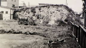
Brickyard origins
Archaeologists will look to the contours of the land and the construction of our modern fixtures as a throughline to the past. Humans have a tendency to repurpose the infrastructure of prior communitie, and we mold our environments onto the patterns of the past. The hill before you, the centerpiece of Brickyard Cove, did not form through forces of nature. Like the shellmounds, it is a remnant of past habitation. Unlike the shellmound, however, it is literally a trash-heap midden. In this spot and further toward the Berkeley marina are the sites of two former landfills. Much of the refuse at this particular landfill was masonry rubble and bricks from the 9,000 buildings that were demolished during construction of the Bart line through West Berkeley and Oakland in the 1960s. You are witness to a strange succession of events. Across earth, we have the life stories of plants and animals and humans woven together. Ecosystems grow and transform as species arrive and vanish, climates change, and disturbances rock the landscape. The story of the people who have lived here—stories of urban renewal and gentrification, immigration and emigration, political discontent and the burried legacy of genocide, continue to tear apart and reassemble the pieces of this place. At this spot, a landfill has been reclaimed by hikers, cyclists, and wildlife after years of environmental advocacy. Even still, you may find bits of broken brick, fragments of worn glass, and chips of china that have been rolled by the tidewater or pushed up by the tunneling of gophers and ground squirrels.
Strawberry Creek estuary
From this point, look across the inlet until you can find the outflow of Strawberry Creek. Through a concrete rectangle beneath the bridge, the creek enters into the bay. Here is the culmination of a creek’s somewhat tortured journey. This water rolled off the back of the chest of Berkeley Hills. It percolated through the soil wherever the land was not covered by concrete or asphalt. It careened over sidewalks and down spillways into dingy storm drains. Perhaps you have heard it flood past you when you walked through UC Berkeley’s campus, or sat by a charmed spot along the creek at some point in your life. Maybe you have been out on a quiet night in Berkeley when you have heard the water flow beneath your feet in the pipes and culverts. The existence of this creek system is the reason that Berkeley was chosen as the site for the new University. The creek meets the bay here in a way that is, well, mostly remarkable. And yet life has taken notice of the creek’s arrival. On most days, birds congregate around this outlet and use the freshwater for bathing; look around, you might find ducks or gulls rinsing the salt off their feathers in the fresh stream. The sediment-rich mudflats at low tide offer a buffet of invertebrates for the sandpiper and killdeer that dart across their surface at the water’s edge. Dozens of other bird species, some of them exotic and relatively rare, frequent this location depending on the tide and season. Look carefully and find a few birds that you did not at first notice. Watch them carefully and see what they do.
Tidal mudflats
Now you are approaching the bridge above the Strawberry Creek estuary, such as it is. Approach slowly as you may notice that the birds are responding to your presence. Remember, these are wild creatures and they likely regard your human form as a threat. Millenia of pressure has made these animals wary of bipedal apes. Take a fresh view of the birds that are active here, what can you find? Check the mud on the banks of the Bay by the bridge. Can you find any footprints? In addition to the possible dog or kid, can you find a raccoon hand, an opossum foot, or a duck or gull. Tracking and investigating the signs that animals leave behind is a powerful way to enter their worlds. Oftentimes we can learn more about an animal by tracking them than we could during the brief times that we can actually see them. A skilled tracker could likely recreate a vivid picture of life at this spot by venturing down to the back and checking the mud. Go for it if you feel it is safe to do so!
Find the sinewy course of Strawberry Creek through the mud. The drainage system is transformed with each tide. Notice how the sediments of the Bay are shaped to the outflowing water. At low tide, this drainage course stretches far into the Bay, and at high tide the freshwater system is fully inundated. Look out over the Bay. Given its vastness, and the large ships in the ports, you may be surprised to learn that most of this water is no deeper than 15 feet (5 meters). South of the Bay Bridge, the water in most places is less than 3 feet (1 meter) deep. Big ships are able to pass through the bay because the floor is dredged, clearing deep channels for commercial passage. The little Island that separates the two spans of the Bay Bridge is called Yerba Buena, named for the “good herb,” a sweet-scented perennial that adorns the oak and madrone groves on the island’s shoreline. Fanning out from Yerba Buena is the flat area called Treasure Island, formed from years of artificial deposition from the dredging of these waters.
Turn and look back toward the brickyard. From just behind where the brickyard projects into the bay you will see a tall white apartment building. Beside this building is the site of another shellmound, known as the Emeryville Shellmound. This was one of the largest constructions in the East Bay, measuring 300 feet in length. Like the Berkeley Shellmound, it was plundered and razed post-contact, and it is now overtopped by roads, parking lots, and a shopping district.
Ground squirrels
Ground squirrels (Otospermophilus beecheyi) abound throughout the marina, and if you don’t see the squirrels themselves, you can easily find their trails and burrows. This is a native species that thrives in the presence of humans, using the artificially-placed rocks of the shoreline for shelter, and indulging in the handouts of well-intentioned visitors with their bags of peanuts. The burrow systems of these rodents have multiple entrances and may be more than 100 feet (30 meters) long. The ground squirrels use the burrows for shelter, food storage, and to raise their pups. Along this section of the trail there are several burrow entrances. Look for the holes; look for the worn trails that lead from one hole to another, through their foraging areas. “Spermophilus” (part of their Latin name) means “seed lover,” and these guys are focused on the seed-bearing plants in their vicinity, but they will also eat buds, fruits, and insects. Look out for squirrels scurrying about. Look along the rocks to see if they are perched there as sentinels, on the lookout for hawks overhead or stalking dogs. With their tawny coats and sharp angled bodies they are easy to mistake for the rocks themselves. If you are quiet for a moment, you may also hear their high-pitched chirp, which sounds like the striking of steel and can be easily mistaken for a bird call.
Wild turkeys (Meleagris gallopavo) moved into the marina a few years ago, and they are most active at this place. You may pass them along the trail or see them crossing the roundabout. Turkeys are omnivores that forage for seeds and insects by raking through soil or leaf litter, and you can look for their telltale surface scratchings. Though California once had native turkeys (Meleagris californica), this species went extinct in the late Pleistocene. The turkeys we find today were introduced to California in the late 1900s by officials who brought them from Arizona, New Mexico, and Texas for sport hunting. Over the past 20 years, the turkey population in the East Bay has boomed, and there is active debate as to their ecological impact.
Wind and riprap
As you round the corner, you may be welcomed by a gust of wind. From April to September, as hot air rises in the valley of California, cool coastal air is dragged in to replace it. This pull generates a steady onshore wind from the Pacific Ocean. Wind is named by its source direction, so we call these winds westerlies. Westerly winds are also responsible for pulling in the coastal fog that blankets Berkeley and other coastal ecosystems during the summer months, giving relief to a parched landscape. During winter months, inland California remains cool and the westerly winds become inconsistent, and storm systems produce variable gusts and rainfall. Before colonization, the undeveloped, naturally eroded coastlines of the tule marshes created a natural wind and storm buffer for people living at sea level. It is estimated that over 95% of the original Bay Area marshland has been lost to draining, conversion to agriculture, and development.
The shoreline of the bay is constantly shifting position as a result of erosion and changing sea levels. The force of the tides, wind-generated waves, and storm surges relentlessly pressure the shorelines. The boulders along the shoreline throughout this marina have been placed here to prevent erosion and hold the shape of the banks. These boulders are called riprap and give us another view of the deconstructed city that is also buried beneath the Brickyard landfill. Scanning the riprap you may find volcanic rock that was quarried from Sibley Volcanic Park just a few miles south of Berkeley. Blue and red sandstones were hauled from Mount Saint Helena in the Napa Valley, and colossal cubes of granite are also visible, with an origin story far to the east in the Sierra Nevada.
The shoreline is an important feature of aquatic ecosystems. It is the interface between terrestrial and aquatic worlds. Riprap provides habitat to some organisms, like chitons, limpets, and barnacles that anchor themselves to the surfaces. But the riprap also eliminates the habitat of other organisms, such as the aquatic plants that grow only in shallow water, or the terrestrial animals that forage on the tidal mudflats. As such, the placement of riprap is one of the many ways that humans alter the bay and its ecosystem, to control a Golem that is inherently fluid, moody, and powerful.
The beach
See how the water breaks into white caps in the wind? Sleek black shags—Pelagic Cormorants and Double-crested Cormorants—are strong swimmers that plunge into the pelagic waters in search of small fish. Grebes and Loons are also busy in healthy parts of the Bay. Brown Pelicans wheel overhead, and terns and gulls of several species are common. Smell the air. It is crisp and clean with the unmistakable, dark fragrance of the bay. What you smell is geosmin, a potpourri of sesquiterpenoids, a cocktail of gasses produced by blue-green algae, filamentous bacteria, and other prokaryotes. You may associate geosmin with the smell of a rainstorm, a lake, or the ocean. It’s a smell that reaches to something deep inside us, and hopefully you find it as comforting and familiar as it is primordial. Your olfactory system can detect geosmin in the air at less than 10 parts per trillion (Polak). There are few other fragrances to which we humans are so attuned. Some evolutionary biologists suggest that the capacity to detect this scent may say something of the important connection between water and its support of all life on earth, or as an ancient mechanism to allow us to find water sources. As you can see, this little beach teams with all forms of life, from the birds and barnacles to the little purple crabs that seem to fear their own shadows.
Bye bye fog
On all sides, water. Six major bridges criss-cross the Bay, connecting the big cities at each corner. To the south, you see the Bay Bridge. Directly in front of you, the Golden Gate, and to the north, the Richmond Bridge to San Rafael. A staggering 40% (605 km2) of the San Francisco Bay has been filled since 1850. That means 40% of the marshes and estuaries that once flourished with life have been converted to shipyards, industrial buildings, apartment blocks, and luxury highrises. But the tide keeps coming. By 2040, it is estimated that 200,000 Bay Area residents currently live in a location that will be inundated. Already, 355,00 Bay Area residents are directly impacted by sea-level rise. This includes the severe winter flooding seen in West Oakland, and the toxins displaced by a rising water table that now threatens the health of San Francisco’s Bayview-Hunters Point community. Living on the edge of the Pacific, the tide is a twice daily reminder of the ecological precarities of this era. Learning how we as a species can live in harmony with the natural world begins with the recognition that the forces of the ocean and atmosphere are not within our control, and that we do not need such control to be prosperous and fulfilled.
Bye bye fog see you later
Tell the egrets wait for me
Give my love to shoreline breezes
So long ocean view
We’ll be back beside the bay