Orientation
You are probably familiar with the idea of tectonic plates, the enormous chunks of Earth’s crust that float around on a viscous mantle and that constitute the continents and ocean floors. Over geologic time, tectonic plates drift, crash, subduct, melt into the mantle, and rise again to form fresh crust at the seams. During the reign of the dinosaurs, the ancient Farallon Plate collided with the North American Plate and subducted beneath it. The Farallon Plate disappeared almost entirely under North America, and it dragged the adjacent Pacific Plate into contact with the California coast. The Pacific Plate slides northward past the North American plate along the boundary known as the San Andreas fault. The San Andreas is a transform boundary where the two plates grind past each, generating earthquakes. Although these quakes can be destructive, they are relatively small compared to those that occur at subduction zones. And although transform faults are not normally associated with volcanic activity, the tectonic forces that created volcanism at Sibley are connected to the earthquakes that we experience in the East Bay today.
As the Farallon plate was pulled under the continent, the seam that divides the Farallon and Pacific plates was also subducted. The subduction of this spreading center created a slab window, a gap under the continent that was filled with hot, upwelling mantle, leading to volcanoes! The slab window was initially formed in Southern California around 25 million years ago together with the San Andreas fault system, and both began moving northward along with the Pacific plate. The zone of volcanism reached the Bay Area around 10 million years ago, and the eruptions created Round Top. As the slab window continued northward, the East Bay volcanics went dormant, and new volcanoes arose in Sonoma County. While the volcano at Sibley is extinct, the processes that created it are still very much a work in progress!
Geologists and geology students at Cal have long used Sibley’s rich geology as a training ground for mapping rocks, and much of what we know about the rocks of Round Top volcanics comes from Berkeley scientists. Garniss Curtis was a professor of geology at Cal and a pioneer in the field of geochronology (the dating of rocks with radioactive isotopes). Curtis is best known for dating ancient hominid fossils in Africa, but the rocks of the East Bay Hills were the testing ground for his new methods. Curtis and his students found that Round Top erupted over the course of a few hundred thousand years between 9 and 10 million years ago, during the Miocene period. Stephen Edwards, a Cal grad student, mapped the lava flows and geology of Sibley when he was preparing for his qualifying exam. Edwards designed many of the interpretive signs you will see around the park, and you will find the signage full of valuable information.
Dynamic landscapes
Try to get your bearings here. Find Round Top looming above you, the old volcano now cloaked in eucalyptus trees. Now figure out which way is East, and look out over the hills in that direction. Imagine you are on a Miocene lanscape. To the west, tall mountains loom above what is now San Francisco Bay, and a big river flows from those highlands to the spot where you now stand. The river flows past you, heads east, and empties into the ancient Bay in that direction. The local ecosystem hosts a diversity of massive mammals, including horses, rhinos, lions, saber-toothed cats, camels, and the relatives of mammoths and mastodons called gomphotheres. Fossils from this time period were discovered during the construction of the Caldecott Tunnel (Hwy 24), and some of these are now housed in the UC Museum of Paleontology. When you think about the eruption of Round Top on this field trip, try to imagine this rich, riverine landscape at the edge of the Bay.
Picture 2 © Carl Buell
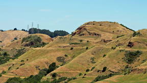
Berkeley ridgeline
If you have walked up to this point, time to catch your breath! Use the sign to orient yourself northward for a close look at the Berkeley ridgeline. Try to find Grizzly Peak and Bald Peak (the latter may be referred to as Vollmer Peak on the sign). The East Bay Hills have risen over the last couple of millions of years, and they are a product of the complex dynamics of local tectonic forces. The East Bay Hills are bounded by the Hayward Fault to the west and the Calaveras Fault to the east, with many local subsidiary faults. The movement of each of the East Bay faults generally reflects the strike-slip nature of the larger San Andreas Fault system, with the western block moving to the northwest and the eastern block to the southeast. However, the faults are not perfectly in parallel, and the combination of transverse and compressive motion leads to transpression, and the transpressive forces crumpled the East Bay landscape, much as your shirt sleeve acquires ridges and valleys when you push it up. As a result of all the folding, the originally horizontal sedimentary layers now form humps and troughs, and some of the rock layers are even vertical in orientation. The rocks of Sibley are part of a trough, or syncline, where the layers tilt down toward the east.
Round Top dike
Now walk around the left side of the water tower, and carefully observe the rock face above you. Note the varying textures of the rock, such as the spheroidal structures and the crumbly, gravely folded areas. In front of the interpretive sign is a vertical band of dark rock. (There is a substantial amount of lichen and buckwheat growing here, so try to find spots where fresh rock is exposed.) This dark, basalt band is one of the most interesting features of the park, particularly to a vulcanologist: it represents a dike, the path that upwelling magma once took through the interior of this volcano. You are standing in the caldera of the volcano, and the dike represents one of the major artery. It is very rare to have such a close view as this. The rocks surrounding the dike include gravelly mudstones, tuff-breccias (consolidated volcanic ash and rubble), and more basalt. Some of the volcanic rocks contain rounded structures with concentric layers. These formed via spheroidal weathering, where chemical weathering and temperature fluctuations created a layered-onion appearance. All of these volcanic rocks are part of the Moraga Formation. A key feature of volcanic rocks is their small grain size--try to see if you can pick out individual crystal grains on exposed rock faces, and consider how their size compares to those you may have seen on plutonic rocks, such as granite (think about the big crystals in a granite countertop). Why do you think volcanic rocks have smaller grain sizes than plutonic rocks like granite which formed from magma that cooled and solidified underground?
Rest and restoration
Take a load off on this nice bench! Check out the vegetation in front of you, both in the foreground and background. The tall trees that serve as the backdrop are mostly blue gum (Eucalyptus globulus), an Australian species that was widely planted in the East Bay where it now forms dense stands. Because eucalyptus burns explosively in hot fires—and because it produces allelochemicals that inhibit the growth of native species—land managers and restoration ecologists advocate for removal of eucalyptus trees from natural areas. Note that in the foreground, where the eucs have been cut, redwood (Sequoia sempervirens) and other tree species have been planted. The cages around these plants help to protect them from hungry deer and human clumsiness. Listen for bird song from this point, and try to find birds overhead or flitting in the vegetation. As soon as you let your mind quiet down you may realize how many birds are audible in all directions. Try to calm your mind for a couple minutes and describe what you hear.
Basalt quarry
The massive pit in front of you is a former gravel quarry that was excavated by during the construction of the Caldecott tunnel in the 1930s. While the hole itself is not a natural feature, it exposes the inner workings of Round Top volcano. The wall opposite you is made up of basalt lava flows that buried the vent of the volcano, forming a sort of cap. Fossil clams and snails have been found in the tuff deposits of this quarry, indicating the occurrence of a freshwater lake that filled the caldera between eruptions. Note the color and texture of the basalt: the rock weathers to a light, yellowish color over time (keep this observation in mind at future stops). Due to the motion of the bounding faults, the rocks at Sibley have been transported to the northwest, and they have been tilted to the east. This means that Round Top was originally located south of where you now stand (relative to land to the east), and structures you see here are laying on their side. If the volcano were to be put right side up again—and your current position is at the railing looking east over the quarry—you would be laying on your back!
Before you depart this spot, be sure to notice the giant stone labyrinth at the bottom of the quarry. On another occasion, when you have the time, head down there to explore!
Orinda Formation
Not all of the rocks in Sibley are volcanic in nature. The exposure here shows layers of cobblestone, sandstone, and siltstone that would have been deposited by rivers running down an alluvial plain towards the paleo-bay to the east. We know the direction of water flow because the individual cobbles in these rocks match the geology of the Franciscan Complex found in San Francisco and the Marin Headlands. Franciscan rocks formed during the subduction of the Farallon Plate under California in the Mesozoic Era (Age of the Dinosaurs). These rocks were uplifted into coastal mountains in the Miocene, and some of the smaller eroded fragments were carried by the river to this spot. The coarseness of the cobbles demonstrates that the ancient river flow was energetic, a common feature in modern alluvial fans with big, fast rivers. These alluvial sedimentary deposits are part of the Orinda Formation, the layer that underlies the Moraga. The environment of the Orinda persisted through the time of Round Top’s eruptions. Note the baked, red color at the top of the layer—this was caused by contact with the hot Round Top lava, and it is something we can study on future stops.
Mudstone
This is a beautiful, quiet stop. Pause in front of the stone labyrinth and face the interpretive sign. Look up and to your left and notice that the the rock is the same as the basalt that you saw in the quarry pit. Now look up and to your right, and try to find the alluvial deposits of the Orinda Formation. Note the orientation of the layers: they were originally horizontal, but they have been tilted dramatically eastward. The Orinda rocks here are finer-grained than at the last stop, and they are more like a silty mudstone. This could either reflect a change in flow energy (for example, if the sediments were deposited at the edge of a channel rather than at the middle) or they could indicate a different sediment source. When the Moraga volcanics were active, the lava flows buried the alluvial deposits, and after the flows had cooled, they would be covered over by new, river-borne sediments. This cycle of inter-bedding, along with tectonic uplift and transpression, created the complex assemblage of rocks that we see today in this area. An important thing to remember when studying sedimentary rocks is that the vertical thickness of a rock layer does not necessarily correlate with how much time it represents. For example, do you think the basalts and mudstones were laid down at similar rates?
Columnar joints
The basalt here is broken up into consistent linear features that at first may appear to be depositional layers because they are currently horizontal. However, these are not bedding layers from successive lava flows or from river or lake deposition. Instead, these are parallel joints that were originally vertical in orientation! The fracture planes were produced through process known as columnar jointing, and it is a relatively common occurrence as lava hardens and contracts as it cools. A dramatic example of this can be seen at Devil’s Postpile near Mammoth in the eastern Sierra. Other famous instances of columnar jointing include Devil’s Tower in Wyoming and Giant’s Causeway off the Irish coast. In these above listed cases, columnar jointing has formed striking, hexagonal pillars, but the joints here are not as neatly geometric. For more on the formation and structure of columnar joints, follow this link.
Tuffs and lava
The sequence of rocks at this stop tells a dramatic story. The dark basalt at the bottom of the sequence is overlain by light-colored tuff, the layers of ash that settled on the hot lava following an eruption. Like the Orinda rocks we saw earlier, the tuffs here are baked red by the heat of the lava. The characteristic red color may be due to the presence of water or steam at the contact horizon. If you look carefully just above the transition from basalt to tuff, you should note a thin black layer. This likely represents a secondary lava flow that occurred as the ash was still settling. Above that are even thinner dark bands: these could represent additional lava flows, or they could be creek bed deposits produced after the eruption.
Basalt flow
This is an excellent spot to appreciate the variety of textures that volcanic rock can exhibit. If you are comfortable climbing up to access the rock, you can go and examine it up close. The many small holes in the rock are the vesicles where gas and steam would have escaped the lava as it surfaced and cooled. Volcanoes can release large amounts of volatile gas into the atmosphere as they erupt, and these small holes are evidence of that process. (This is also a reason that volcanic rocks typically make effective aquifers—their porosity allows them to retain a lot of water. It is also why pumice stone is light weight.) Try to find some of the round 'pebbles' embedded in the basalt. These are known as amygdules, and they occur when minerals from the groundwater seep into, and fill, the vesicles.
Autobrecciation
At first glance, this large rock in front of the sign appears similar to other chunks of basalt that we have seen, and in some ways it is. But check out the crumbly, rough texture on parts of the rock face. These surfaces are evidence of autobrecciation, which means that the rock broke apart as it was still cooling from the liquid state.
Redbeds
This site provides another great example where tuffs were baked by lava. In this case, note that the ash/tuff layer is sandwiched between two basalt flows, and it has been baked red on both sides. Also, observe the extreme tilting of the rocks here. Knowing the layers have been tilted down to the east, can you identify which side was originally up?
Cinder knobs
Take a look at the brick-red cinder knobs indicated by the sign. Cinders, more formally known as scoria, are blobs of basaltic lava that get ejected during a volcanic eruption and harden in the air. They have a fine vesicular texture caused by rapidly escaping gas, and they are commonly red due to oxidation of the iron in the basalt. In this case, multiple chunks of scoria were welded together. Can you notice the differences in the size and arrangement of the vesicles in the scoria compared to the vesicles in the basalt that you observed earlier?
Siesta syncline
Opposite you is the beautiful Siesta Valley, bordered by the low hills in front of you. The valley is the central axis of the Siesta Syncline, and all the rocks in Sibley tilt down toward the valley bottom. The layers that underlie the far hills, on the other side of the valley, tilt down toward us. The rocks in the valley belong to the Siesta Formation; these valley sediments overlie the Moraga volcanics that were produced by Round Top and that we have examined throughout Sibley. The Siesta Formation is characterized by relatively fine sediments that were deposited in a large lake basin about 9.0–8.5 million years ago. When the lava flowed from Round Top, the blocking of creeks and small rivers created ponds and small lakes. During subsequent periods, tectonic movements within the East Bay fault system created the large lacustrine ecosystem that produced the Siesta Formation deposits.
Congratulations on the completion of this tour of Sibley!