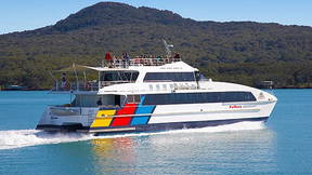
Downtown Ferry Terminal
To catch the ferry from Downtown Auckland to Oneroa (Waiheke Island), you'll need to go to Pier 11 when travelling with Fullers360 and Pier 13 when travelling with Island Direct. Alternatively, you can also use Fullers360's Waiheke Reserve ferry, which departs from Pier 13 and Pier 14 at the Downtown Ferry Terminal.
Island Direct Ferry:
- Tickets: Tickets can be bought online on the Island Direct website or at the terminal.
- Boarding: Board at Downtown Auckland (Pier 13).
- Payment: AT HOP card or contactless payment methods are accepted for single trips.
Waiheke (Reserve) Ferry (Fullers360):
- Tickets: Pre-book your tickets online and specify your preferred departure time.
- Boarding: Board at Pier 11/13 at the Downtown Ferry Terminal. Boarding opens up 15 minutes prior to departure.
- Payment: Pre-book for the Reserve Ferry, Walk-up tickets can be bought online or at the pier terminal
Downtown Ferry Terminal:
- Location: Located on 107 Quay Street in Auckland.
- Piers: Ferries depart from various Piers (1-14) to various locations.
North Head
North Head (Maungauika) stands as a sentinel at the entrance to Auckland’s harbour. For centuries, it was a strategic Māori pā (fortified village) and a place of deep cultural significance. With the arrival of Europeans, it became a key coastal defense site, complete with tunnels, gun emplacements, and military barracks built to guard against potential Russian invasions in the late 1800s. During both World Wars, it remained an active military base. Today, North Head is a historic reserve, offering visitors scenic walking tracks, hidden tunnels to explore, and stunning views across the Hauraki Gulf—its military past blending with peaceful parkland.
Bean Rock
Bean Rock is a small but vital landmark in Auckland’s harbour, named after Royal Navy Lieutenant P.C. Bean, who first charted it in 1840. Hidden beneath the waterline at high tide, this rocky outcrop posed a serious hazard to ships navigating the busy Waitematā Harbour. To protect maritime traffic, the distinctive Bean Rock Lighthouse was built in 1871—the oldest wooden lighthouse still standing on its original platform in New Zealand. For over 150 years, it has safely guided vessels into Auckland’s port. Today, while fully automated, Bean Rock remains a cherished piece of maritime history, symbolizing Auckland’s seafaring heritage.
Rangitoto
Rangitoto is Auckland’s youngest and most iconic volcano, rising from the sea around 600 years ago after fiery eruptions shaped its distinctive cone. Its name means “Bloody Sky” in Māori, linked to legends of fierce battles. For centuries, Rangitoto stood as a sacred landmark, later becoming a source of scoria rock for Auckland’s roads and buildings. In the early 1900s, small holiday baches were built on its shores, some of which still stand today as historic relics. Now a pest-free scenic reserve, Rangitoto is a haven for native birds and walkers, offering stunning summit views, lava caves, and rich volcanic landscapes.
Musick Point
Musick Point, or Te Naupata, is a dramatic headland overlooking the Hauraki Gulf near Howick. Once a fortified Māori pā site, it was an important strategic lookout for local iwi. In the 20th century, the headland was chosen for a new kind of defence—radio communication. Named after American aviator Captain Edwin Musick, who pioneered trans-Pacific air routes, Musick Point became the site of a state-of-the-art radio station in 1942. It played a vital role in wartime and early aviation, keeping ships and planes connected across vast oceans. Today, the art deco radio building still stands, and Musick Point is known for its panoramic views, golf course, and historical charm—a place where ancient heritage meets the golden age of radio.
Brown Island
Brown’s Island, or Motukorea—meaning “island of the pied oystercatcher”—is one of the best-preserved volcanic cones in the Hauraki Gulf. Formed around 20,000 years ago, it was home to some of the earliest Māori settlers in the region, who cultivated its rich soil and built fortified pā on its slopes. Its strategic location and fertile land made it highly valued. In the 1840s, it was purchased by William Brown, Auckland’s first mayor, giving the island its English name. Unlike many other cones, Motukorea was never quarried, leaving its volcanic shape and Māori terraces intact. Today, it’s a protected reserve, visited by kayakers and boaties who come to explore its walking tracks, learn its layered history, and enjoy sweeping views of the Waitematā.
Motutapu Island
Motutapu, meaning "sacred island," is one of the oldest landforms in the Hauraki Gulf, with a history stretching back over 180 million years. Once heavily forested and home to thriving Māori communities, the island’s landscape was dramatically reshaped around 600 years ago when neighbouring Rangitoto erupted—covering Motutapu in volcanic ash and preserving archaeological traces of early life. In the 19th and 20th centuries, it became farmland and a strategic military site during World War II, with gun emplacements still visible today. Now, Motutapu is a remarkable conservation success story: cleared of pests and restored with over 500,000 native trees, it’s a sanctuary for rare species like the takahe and a tranquil destination for walkers, campers, and history lovers alike.
Motuhie Island
Motuihe Island, known as Te Motu-a-Ihenga, has a rich and layered history stretching back over 800 years. First settled by Māori, it was prized for its sheltered bays, fertile soil, and strategic location in the Hauraki Gulf. In the 19th century, it became a quarantine station for arriving ships, then later a naval training base and even a World War I internment camp—where the famous Count Felix von Luckner was held (and briefly escaped!). Over time, farming and human activity damaged the island’s ecosystem, but in recent decades, an ambitious restoration project has transformed Motuihe into a flourishing wildlife sanctuary. Today, it’s a haven for native birds, tuatara, and peaceful day-trippers who walk its tracks and swim in its pristine waters.
Matiatia Headland
The headland at Matiatia marks the gateway to Waiheke Island—a place of first impressions and deep history. Once home to Māori settlements, this coastal ridge offered shelter, lookout points, and abundant kaimoana (seafood). Its strategic position made it a key arrival and departure point long before ferries connected Waiheke to the mainland. In later years, the headland became a pastoral landscape, shaped by farming and sea trade. Today, it stands as a natural welcome mat for visitors arriving by ferry, offering walking tracks, native bush, and sweeping views across the Hauraki Gulf. As the island’s transport and tourism hub, Matiatia’s headland continues its role as a place of passage—where stories begin, and adventures unfold.
The headland at Matiatia is more than a scenic arrival point—it's a place of deep ancestral connection.
Traditionally known as part of the rohe (territory) of Ngāti Paoa, this area was once home to thriving Māori communities who lived in harmony with the land and sea. The natural harbour provided a sheltered anchorage for waka (canoes), while the headland offered a strategic vantage point and rich access to kai moana (seafood). The name Matiatia itself is believed to be derived from Māori origins, though interpretations vary—some say it refers to the calming of waters or the whisper of the tides.
For generations, this place was a threshold between journeys—whether arriving by sea or departing inland along ancestral trails. Today, as ferries glide in and visitors step onto the island, the headland still serves as a place of welcome (manaakitanga), echoing the footsteps and guardianship of those who came long before.
“Mokee mokee Pā situated at the northern entrance to Matiatia bay is a powerful, conspicuous remnant of Ngāti Paoa’s history on the island. It was a strategic defensive outpost for the western portion of Te Huruhi prior to the introduction of the musket. The pā is relatively small, and supported the people of Matiatia Bay in times of warfare. Mokee mokee Pā is a sentinel that watches over the Bay and its environment.”- Morehu Wilson, Ngāti Paoa
1700s - Mokemoke Pā the northern headland
“Mokemoke Pā situated at the northern entrance to Matiatia bay is a powerful, conspicuous remnant of Ngāti Paoa’s history on the island. It was a strategic defensive outpost for the western portion of Te Huruhi prior to the introduction of the musket. The pā is relatively small, and supported the people of Matiatia Bay in times of warfare. Mokemoke Pā is a sentinel that watches over the Bay and its environment.”
- Morehu Wilson, Ngāti Paoa