Introduction
Text for this tour has been kindly provided by Auckland Council.
This walk guides you past historic interest points, known locally as Takapuna's 'Golden Mile'. While a considerable amount of expensive development has happened along this stretch over recent decades, much of its historic architecture, flora and geology has been preserved and makes for a fascinating landscape.
Even in the early days, the area around Takapuna and Milford Beaches and Lake Pupuke was where wealthy Auckland businessmen built homes for their families. These houses were usually their second home where the family spent the summer months entertaining and relaxing in rural surroundings. Their town houses were usually in the heart of the business district in Symonds St or Grafton. Many of these families grew so attached to their summer houses on the North Shore that they moved here permanently and commuted to town daily. Families such as the Hursts, Alisons, Pierces, O'Neills and Bretts have become established names in Takapuna, and are remembered in some street names.
Takapuna and Milford Beaches were 'Pleasure Gardens', places for family day trips and picnics. The Devonport Steam Ferry Co had a regular service to the North Shore. You could step out straight on to the beach at the Takapuna wharf (where the boat ramp currently is) or catch the steam tram from Bayswater along Hurstmere Rd to Milford.
Text for this tour is Copyright Auckland Council.
Practical Information
Terrain
Roads, a paved promenade, beach and some lava rocks. Part of the walk follows the coastline and is only possible at low tide.
Duration
Minimum 2 hours.
Parking
Parking is available near the Takapuna boat ramp or at the end of Muritai Road near Milford Beach.
Privacy
The walk is mainly along public road and paths and highlights historical facts about the buildings and the area. We recommend the walk be undertaken at low tide when the fossil forest is most visible and the foreshore more accessible.
Part of the route, between Milford and Takapuna Beach, follows the foreshore and crosses private property thanks to the owners' goodwill. Please respect the environment and the privacy of local residents, and do not trespass on private property outside the described route. The pathway in this area is not properly constructed so please take care. Part of the charm of the walk is the natural state of the paths, particularly near the fossil forest.
Neither Auckland Council nor the private property owners accept any responsibility for any loss, damage or injury to you or your property arising from your use of this walkway.
The Pohutukawa and the Mon Desir
Start at the Takapuna boat ramp on The Promenade, on your left towards the main road you will see...
This cluster of magnificent pohutukawa trees is over 200 years old. The trees are part of the sacred grove referred to by Maori as Te Urutapu which extends from here to Thorne Bay. Travellers passing the sacred trees would place floral tributes at the foot or hang garments in them as a mark of respect to the spirits to ensure safe travelling. Pohutukawa grow only along North Island coastlines producing bright red flowers in December which are a symbol for Christmas in New Zealand. These trees were on the Mon Desir Hotel property, a popular holiday destination and North Shore landmark for many years. Its last building, the Public Bar was demolished in 1996 and the Mon Desir Apartments took its place.
Walk up The Promenade and turn right into Alison Ave with views of the beach and Rangitoto Island on your right.
This area was a four-acre section below E. W. Alison's house Lochaber. The paddock, next to the reef and ferry wharf, was used for a house cow and to tether racehorses that were exercised along Takapuna Beach. Increasingly being used as a picnic area, it became popularly known as Alison's Paddock. Alison, was once mayor of Devonport, and was also chairman of the Board of Directors for the Devonport Steam Ferry Company. He transferred this land to his firm in 1912 and the company later built 14 holiday cabins to establish the Takapuna Beach Holiday Park.
Old Telephone Exchange
Turn left into Earnoch Ave. Towards the end of the road is the old telephone exchange (2/187a Hurstmere Rd).
Built in 1920 to accommodate a rapidly expanding telephone network. Subdividing of large estates for seaside housing in the previous decade had placed great demand on the newly opened corner post office and it no longer had room for telephone functions. This plastered brick building was built next door in a stripped Classical style.
Old Post Office
on the corner is the old post office (1/187a Hurstmere Rd).
Opened in 1914, this former post office was designed by the Ministry of Works under the Government Architect, John Campbell, in an Arts and Craft style. It was one of many community post offices built in this period as part of a government programme to improve communication. The site was purchased in 1911, but building was delayed by a petition presented to the House of Representatives by local residents and the Borough Council who both wanted a post office closer to the town centre. However, their plea was ignored. In spite of its location the post office played a pivotal role in the community and carried out a wide range of tasks. During the depression in the 1930s, clothing was distributed from here to the unemployed. The only break in its continuous operation was in 1918 when regular hours were abandoned because of the flu epidemic. Older residents remember the loud clatter of the telegraph's double click when sending telegram messages by Morse code. By 1964 the post office had been superseded by a more centrally located building in Hurstmere Road. It finally closed in 1988 and was later sold.
Earnoch
Turn right into Hurstmere Rd and cross the busy road. On the left hand-side, up a right of way is Earnoch (194-196 Hurstmere Rd).
Now a hairdressing boutique, this simple gabled homestead, built in 1876, was home to well-known Auckland businessman, John Roberton. The family called the estate Earnoch after the area in Lanarkshire from where their ancestors came. They tried to make the house their permanent home in 1884 but commuting to Auckland City was not easy so they moved back to town. Although most of the land has been subdivided, the homestead is largely unchanged.
Bradninch
Back on Hurstmere Rd, a few houses along on the left is Bradninch (208-210 Hurstmere Rd).
This huge three-storey, Moderne style concrete house (now almost completely hidden by the front hedge) was built by George Nicks as a new home from his previous house across the road at 207. Nicks had a timber mill in Northcroft St, Takapuna and was well established in the community, having already developed sections in Hurstmere Rd and Brett Ave. Built around 1943, the Art Deco corners and curves make this house very different to his earlier home across the road. Nicks called it Bradninch after a village in Devon.
White Oaks
A few houses along on the right is White Oaks (203 Hurstmere Rd).
White Oaks stands on what was known as Nixieland because it was part of an extensive property owned by the Nicks family. In 1908 Mary Ann Nicks bought the land from Jessi Craig, wife of J. J. Craig. She had only a very simple beach cottage on the property and it was her son George who developed the land profitably. At the same time as he built his family home at 207, he bought his sister's and half- brother's shares of Mrs Nicks' estate and built two more houses, for resale. White Oaks is one of them. Of a slightly later period than its neighbour Brown Gables, White Oaks is constructed of cedar with marseille (now decramastic) tiles. The local media described the interior as oak with rimu panelling, rimu scotias in the doorways and exposed beams, before the estate was put up for auction in 1986.
Brown Gables
and Brown Gables (207 Hurstmere Rd).
Shortly after World War I, Nicks built his family home in the fashionable English Cottage style, characterised by bold rooflines and large picture windows. The house was built with the finest timber from his mill, the exterior being kauri weatherboard and finished with the best materials. All the windows have lead canes.
Subsequent owners have modernised and added their own touches to the property such as the portico in the mid-1990s, but the house still retains its original feel. Note the giant phoenix palm in the front garden which possibly dates back to William Hurst's tree planting efforts in the 1860s when the area along the seaside of The North Rd (as Hurstmere Rd was then called) was Hurst's 'Plantation'.
Hurstmere
Continue along. Opposite Minnehaha Ave is Hurstmere (288 Hurstmere Rd).
This homestead was built in 1860 for prominent Auckland businessman and mayor, William J Hurst. The house, called Hurstmere, originally stood on what was known simply as The Drive. It is built of pit sawn heart kauri using handmade nails and originally had a shingle clad roof. When the shingles began to wear, they were covered with the present corrugated iron roofing. The veranda, garage, upper storey and window awnings were also added later. The house, built early in Auckland's history, pre-dates many Auckland historic houses, including the NZ Historic Places Trust house museums Alberton, Highwic and Ewelme Cottage.
Hurst owned all of the land from Killarney St to the Wairau Stream. He covered the seaward side of the road with trees, many of which still stand today. This part of his estate called 'The Plantation' had a large orchard, pine grove and native trees. Hurst's neighbours at the time were John Roberton, the original owner of Earnoch, Rev. Houchen, an Anglican priest and George Pierce, the general manager of the NZ Fire Insurance Company.
After his death in 1886, his widow subdivided the land twice. The Nicks and O'Neill families bought sections of the land in the early 1900s and became long-term residents in the area.
The Hurst Trees
Looking down Minnehaha Ave and O'Neills Ave, you will see oak trees protruding into the road. The trees, thought to have been planted in the 1860s, were considered a precious feature of the landscape when the two roads were laid around the early 1920s. Mrs O'Neill who owned property on the cliffs successfully campaigned to preserve the two trees
in O'Neill's Ave.
One theory suggests that the two oak trees flanking Minnehaha Ave were planted by William Hurst to frame his house. The effect of the two trees now large enough to meet in an archway, can still be seen today by walking a little way down Minnehaha Ave and turning back to look at the Hurst homestead.
Algie's Castle
Continue along. At one point, you can see Lake Pupuke on the left and Rangitoto Island on the right is Algie's Castle (253 Hurstmere Rd).
When 70 year old Captain John Alexander Algie returned from a trip to his ancestral Scotland in 1924, he brought back a new wife, Penelope, and a passion for all things Scottish. Having decided to spend the rest of his years on the Shore, he consulted with architect W.H. Jaime and together with stonemason Frank Savidan, began building the castle of his ancestral dreams.
Merkesworth Castle, as it was called, is a two-storey baronial home. A tower with 2ft thick locally quarried basalt walls and crenellations overhangs the sea at the back. Reminders of Scotland can be seen everywhere in the house, inside and out. Stained glass crests with the family motto, 'gang warily' are woven into the windows. The initials of John and Penelope are carved above the entrance along with the completion date of the castle, 1926. Captain Algie's prize acquisition from his trip to Scotland, Amoral Bearings is also proudly displayed. Merkesworth Castle is still owned by the Algie family today.
Black Rock/The Stables
Continue along to Black Rock/The Stables (17 Kitchener Rd).
This simple cottage made of heart kauri was built around 1886 by Auckland businessman George Patrick Pierce. The land was bought with riparian rights which means the buyers own all of the land down to the high tide mark on the shore line. This included the black lava rock (see 14 to 18 ) on the beach which formed after the eruption of Lake Pupuke 100,000 years before. Pierce liked the idea of owning part of a volcano and called his estate Black Rock.
The house, while an adequate size for the large family as a summer cottage, was much simpler than some of the other grand mansions in the area. It passed out of Pierce hands after George's death in 1891 and it wasn't until the 1980s that it got its new name 'The Stables'.
The Circle/Goldie House
Continue along to the Muritai Rd corner, to your left you should see The Circle/Goldie House (90 Kitchener Rd).
The circular apartment building peering out above the trees was built in 1968 and was recognised as the first apartment tower in New Zealand to have 360° views. At the time, it was an impressive 11 storeys high with 12 apartments and took two years to complete. Named 'The Circle', it was built on the site of 'Maratea', the Goldie family's summer house. Charles Goldie, the acclaimed painter of Maori portraits made considerable use of the studio his father had built for him there. Tales of parties and weekends held at the house have become legend among Shore residents. Two Norfolk pines, traditionally planted in pairs, were retained when the ageing house was demolished to make way for The Circle. However, lightning struck one of the pines in 1969 so only one can be seen standing tall, as if competing in height with The Circle today.
Porthcurnow East
Turn right into Muritai Rd, halfway down is Porthcurnow East (14 Muritai Rd).
Anglican Clergyman, Reverend Edward Houchen bought 10 acres of land and built his family a simple double gabled house in the late 1880s. He called it Porthcurnow after Porthcurno in Lands End, in southern England, where the family used to holiday. It was one of only two houses in the area and is likely that one gable was built first for the family to live in while the other was completed. Once settled in, the Houchens began expanding, including the addition of a veranda which encircled the house. When Rev. Houchen died in 1903 his daughter Grace turned it into a convalescent home. The two gables were separated and a middle section inserted.
In 1911, the land was subdivided, split into two houses and by 1940 sold to different owners. In 1949, Mary and Albert Nelson Duder, members of the well-known Devonport pioneer family, bought the Ocean View Rd section of Porthcurnow. The house became known as both The Duder House and for a short time Warrawee. The Ocean View Rd section of the Porthcurnow house was recently relocated to Laingholm in Waitakere City.
Mirror House
A couple of houses along, just past the pumping station is Mirror House.
Designed in 1984 by Swan Railley Paterson the house is a remarkable example of late-modernist architecture and parodies buildings of the 1980s while making clever references to its immediate environment. With its hull-like curves, stainless steel railings, flagpole and chimneys that resemble funnels, it suggests a giant mirrored cruise liner in the league of the Titanic. The way it towers over and dwarfs the neighbouring cottage, as a cruise ship would a tugboat, gives the impression of majesty.
The most notable feature of the house is the mirror cladding which is striking both to the eye and the sun. With marvellous views of the beach and Rangitoto, the house is in fact quite insular, as if hiding behind mirrored sunglasses, so that passers-by have no idea what is going on behind the façade.
Firth Cottage
Walk along the wooden bridge, at the end is Firth Cottage.
Portrait photographer Clifton Firth, his wife and three children moved into this bach, one of the original cottages in Thorne Bay in the 1920s. Milford Beach was covered with beach houses at the time, mostly rustic, basic houses but sufficiently comfortable for weekends and family holidays.
The Firths grew so fond of their holiday home that they made it their permanent base, sticking with the small cottage rather than upgrading to something larger. Nestled in a garden among pohutukawa with beach facing windows and a covered porch providing good views and shelter from harbour storms, it is a classic example of a New Zealand bach, and one of the few remaining on this stretch of beach. The Firths relished their casual lifestyle where local penguins felt free to nest under the house and generally make themselves at home.
When the mirror house went up next door in 1984, Mrs Firth said that she appreciated the extra light it provided as the sun reflected off the glass and into her kitchen and garden.
Chapple House
Continue along, at the end of the concrete wall built around the pohutukawa tree is Chapple House.
Architect Mike Austin was hired by Win Chapple in 1967 to design a house in Thorne Bay. The brief stated the house was to be straightforward, that the occupants were not interested in ostentatious or obvious displays of money and it had to fit in with the existing natural landscape. This included gnarled pohutukawa trees, one of which encroached on potential house space, and the lava flow rock which made up the shoreline. Using rocks collected by the family, stonemason Sven Hansen built rock walls 20ft from the house to separate it from the sea. Neighbours commented that on stormy days it appeared as if the house were floating as the sea washed over the rocks.
The multi-layered building which steps down the slope to the beach is the result of a combined effort by professionals, family and helpers. It resembles 'a collection of army huts' with weathered exterior walls and an aluminium roof. This house was built at a time when architects were experimenting with a New Zealand identity. It represents a progression from the simple style of Vernon Brown's Early Modern house to a New Zealand architecture that is more complex in its response to our environment.
Sea Walls and the Giants Chair
Continue walking along to the sea walls and the giants chair.
The walls and chair have the castle theme of Algie's creation (see 10 ) but with more of an edge of fantasy compared to the traditional baronial look of Merkesworth. The crenellated walls along the shorefront with their cathedral windows and towers are more Jack and the Beanstalk than traditional Scotland.
The 'Giant's Chair' or 'Throne', at the end of the wall, was made for Mr W. Leaning. Frank Savidan was commissioned by Thorne Bay residents to build stone walls along the beach to hold back the sea. A sprightly 70-year-old Captain Algie was responsible for building some of the walls himself.
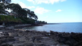
The Fossil Forest
Walk across Thorne Bay. Local residents in the 1930s-40s clubbed together to form concrete footpaths over some of the rougher surfaces. You will see natural drains flowing from Lake Pupuke into the sea. You can reach the main road from any of the side streets or continue along the rocks (be prepared to climb over rocks) to see the Fossil Forest. Just past O'Neills Ave and the boat ramp is The Fossil Forest.
Bordered by O'Neills, Brett and Earnoch Aves and The Promenade
About 100,000 years ago the sea level was much lower and kauri, pohutukawa and mixed broadleaf trees covered the coast. Around this time a crater which is now now Lake Pupuke erupted covering the forest area in hot lava.
The lava covered trees turned into flaming torches or rotted inside the basalt crust when it cooled and turned into a hard shell. Perfectly formed hollow imprints of the trunks detailing bark and leaves were left and can be seen today, some lying horizontal in the rock face and others standing upright. One of these, a 1.6m diameter, 3m deep kauri trunk has been covered by grating for safety and is often mistaken for a well.
The elliptical (oval shaped) holes dotted along the coastal basalt walls were caused by gas blisters in the lava as the outer layer of the lava cooled. These along with moulds of trees or large branches that were caught up and carried along by the flowing lava can be seen in the bank between O'Neills and Brett Aves.
At low tide the remnants of 500 tree stumps can be seen on the reef by the boat ramp. These tree moulds formed when fluid lava congealed around standing trees. Most of the lava then flowed away, leaving isolated stumps of basalt where the trees once stood. It is New Zealand's only example of a fossil forest.
The End
We hope you've enjoyed this heritage walk.
Acknowledgements
Thank you to Louise Anderson for researching and writing this guide and to Greg Bowron and Johanna Barnett for their significant contribution.
© January 2002. North Shore City Council holds all copyrights associated with this document. You may not copy or reproduce the content of any of these pages without permission from North Shore City Council. North Shore City Council has taken every care to ensure that the information contained in this tour is complete and accurate. North Shore City Council accepts no responsibility arising from, or in connection with, your use of this leaflet and the information contained in it.