Introduction
The Waterfront Area of the Fledgling Settlement of Auckland Was Markedly Different from That Which Is Seen Today.
Initially Fore Street (now Fort Street) ran along the beach. By 1870 the shoreline had beenchanged with the reclamation of Commercial Bay reaching as far as Customs Street East and the formation of Quay Street in the 1880s.
Auckland's newest land was close to crucial means of transport. Not only was it on the doorstep of the wharves but soon the new railway station would be at its hub and the heart of the country's largest commercial centre was just a stones throw away.
The extensive development of wharves and surrounding coastal land during the 1870s and 1880s helped Auckland become the country's re-export trading capital.
The 1870s investment boom encouraged the growth of Auckland's industries. Merchants and factory owners alike saw the advantages of land close to the port of Auckland. From the 1880s the area bounded by Customs, Queen, Quay and Breakwater Streets was developed with warehouses, factories, shipping offices and a 24-hour flour mill. The city's most prominent businesses were well represented in the area.
The depression of the late 1880s and 1890s halted further development for a number of years, but the first decade of the twentieth century witnessed a flurry of building activity in the downtown area.
No doubt, the promise of further harbour improvements spurred on local businesses. In 1899 the Auckland Harbour Board adopted a plan to extend the wharf facilities. Work on Queens Wharf began in 1907 and in 1912 the northern side of Quay Street was adorned with the new Ferry Building. Further improvements were made over the following years.
The eastern ends of Customs and Quay Streets had become the favoured location of warehousing and shipping enterprises. It was a bustling, noisy place with trains entering and exiting the railway station and goods making their way to and from the ships, trains and warehouses in the area. In 1912 railway tracks were installed in Quay Street to connect the railway station with the wharves. Trains would travel the street alongside other vehicles for more than 60 years to come.
Today the downtown area to the east of Queen Street stands in stark contrast to the area to the west. While the western side was extensively redeveloped in the 1960s and 70s the eastern side has retained much of its late nineteenth and early twentieth century architecture.
Acknowledgements
Text for this tour is Copyright Auckland Council.
Text for this tour has been kindly provided by Auckland Council.
The Establishment of Early Auckland
The narrow Auckland isthmus, located between the Pacific Ocean and the Tasman Sea, was well known to the great Polynesian navigators who settled Aotearoa (New Zealand) a thousand years ago.
Ta-maki Herenga Waka – 'Ta-maki – the Destination of Voyagers' is an ancient name for the Auckland Isthmus. Waka (canoes) arriving from the Pacific Islands with new seed stocks and migrants sought the narrowest part of the isthmus at Ota-huhu in south Auckland, with its 800m portage between our two great oceans. Later voyagers found Ta-maki heavily populated. Some married into local communities while others continued south in search of new lands. With excellent gardening soils, fish stocks and natural fortifications - the volcanic cones - Ta-maki became and still is today, the centre of the largest Maori civilisation in the world.
Through Hua Kaiwaka's leadership the various tribes of the Ta-maki Isthmus were united under the confederation known as Te Waiohua. Under his reign, Ta-maki saw an unprecedented period of peace and prosperity that lead to sayings such as : 'Te pai me te whai rawa o Tamaki'; 'The wealth and luxury of Tamaki'.
Ngati Whatua, provoked into attack by Te Waiohua in the mid seventeenth century, took control of the Isthmus through peace marriages and occupation of the volcanic fortresses. However, peace would be interrupted again two generations later as the local tribes were displaced during the inter-tribal 'Musket Wars' that engulfed the country from 1820 to 1840.
In September 1840 Ngati Whatua leader Te Kawau gifted 3000 acres of land to Governor Hobson on behalf of the crown. The central commercial district of modern Auckland was included in this gift that established the city. Te Kawau sought military protection, new medicines and trade to bring peace and prosperity to his people. Within 20 years he had lost nearly all his land and was shut out of city administration and governance. Despite this, his descendants have today recovered much of their valuable land in central Auckland and are significant contributors to the local economy and cultural life of the city.
The first group of settlers and government officials travelled from Russell in the Bay of Islands to Auckland on the Anna Watson in late September 1840. Auckland was chosen as the capital of New Zealand because, like Maori before them, the colonial government recognised its strategic location with access to the Waitemata, Manukau and Kaipara Harbours and to the interior of the North Island by way of the Waikato River. It remained the capital until 1865 when the function was transferred to Wellington. From the outset, Commercial Bay at the base of Queen Street was the commercial centre of the settlement. In 1841 Surveyor General, Felton Mathew, drew up a plan for the new city. His starting point was the Waihorotiu Stream, later dubbed the "Ligar Canal"�, which ran down present-day Queen Street into Commercial Bay. Though parts of the plan were later abandoned, Mathew's design provides the layout for many of the city's main streets and the reclamations of Freemans Bay, Commercial Bay and Mechanics Bay.
By 1844 Queen, Princes and Shortland streets were formed and metalled. The government centre developed around the Princes Street area where soon were located Government House, the parliament, the court and the barracks for the British 58th Regiment as well as the substantial homes of many of Auckland's leading citizens. Shortland Street, which linked Commercial Bay with the government centre, became the first and most developed commercial thoroughfare in the city.
Auckland grew rapidly. By 1841 the population was 2000, made up of settlers relocating from the Bay of Islands, immigrants from Australia and Great Britain, and Maori. Religious orders also made Auckland their base with large land holdings being established by the Roman Catholic Church in Freemans Bay and the Church of England in Parnell. The early commercial life of the settlement was based on gum, timber, flax, and fat stock farming and re-exporting to other settlements.
While initial development focussed on Commercial Bay at the bottom of Queen Street, by 1864 the limits of Auckland were Parnell in the east and Freemans Bay in the west. During the 1860s, after the drainage and health problems caused by the Ligar Canal had been resolved, Queen Street began to progressively overtake Shortland Street as the predominant commercial strip. Substantial reclamation of the Waitemata Harbour was carried out during the 1860s and 1870s and continued throughout the 1880s. Auckland soon became the major port in northern New Zealand and a chief port of call for the Pacific.
During the 1870s and 1880s there was a great surge in immigration. The population expanded from 7000 in 1861 to 33,000 in 1886. This led to great commercial expansion and the building of more substantial masonry buildings of two and three storeys. In this period the art gallery and library, the hospital and many churches, hotels and
commercial buildings were constructed.
Progressive periods of redevelopment reinforced Queen Street as the commercial, retail, transportation and entertainment hub of Auckland. After the 1920s the mixture of residential, warehousing and industrial uses in the inner city were steadily replaced by commercial uses. Recent development in the central area has seen a more vibrant mixture of residential and commercial uses occur. A growing interest in the history of the city has led to the retention of many of Auckland's significant heritage buildings.
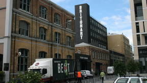
Former Chief Post Office/Britomart Transport Centre
Begin on Queen Street Under the Glass canopy opposite the front entrance of the Britomart Transport Centre.
Work on this impressive Chief Post Office (CPO) building began in 1910 with Christchurch firm J. & W. Jamieson being the chief contractors. It was designed by the government architect John Campbell. On 20 November 1912 the building was opened by the Prime Minister William Massey watched by a crowd of more than eight thousand.
Over the years generations of Aucklanders visited the building to post mail, collect pensions and ration books, pay taxes, and obtain car and radio licences. The CPO also served as a savings bank, insurance office and the central telephone exchange for decades. The CPO was closed in 1992 and was recently restored and reborn as the entrance to the Britomart station, Auckland's central transport centre.
Ahi Ka
Walk a few metres north along Queen Street to the corner of Queen and Quay Streets.
With the support of Auckland City and Trethewey Granite and Marble, this elegantly carved basalt boulder was installed by Ngati Whatua artisans as part of the refurbishment of the Britomart complex and QE2 Square in 2003. Nagti Whatua are the Tangata Whenua (people of the land) of Auckland. The artwork represents mana (tribal authority) and recognises Ngati Whatua's ahi ka-status (enduring 'fires of occupation') and their responsibility as the host tribe to care for visitors and the environment.
Endean's Building
Endeans Building, to the left of the CPO, was completed in 1915, and designed by architects Chilwell & Trevithick. It originally included nine shops and ninety offices for lease.
The original owner, John Endean, had made his money through goldmining in Australia, North America and New Zealand before settling in Auckland where he ran the Waitemata Hotel and speculated in mining. His wife Ellen was a shrewd investor in her own right and involved herself in politics, becoming the first woman to stand for election to the Auckland City Council in 1894.
Ferry Building and Harbour Board Railings, Gates and Lamps
Completed in 1912 on its prominent harbour edge site, the Ferry Building was erected by the Auckland Harbour Board as part of a wider improvement programme for the dock area. It was designed by architect Alexander Wiseman in the Imperial Baroque style. The building provided office accommodation and access to the ferry wharves that gave the only speedy connection between the city and the North Shore prior to the erection of the Auckland Harbour Bridge in the 1950s. It remains a well-used facility for large numbers of ferry users, visitors and locals.
To the east of the Ferry Building are red railings and gates closing off the port area from the street. The gates, which were imported from Britain, display the Auckland Harbour Board monogram on a shield and the piers feature lamps resting on four winds figureheads. The railings, gates and lamps were progressively installed in several contracts between 1912 and 1925. In 1951 this barrier separated the watersiders from strikebreakers during one of New Zealand's most significant industrial disputes.
Maritime Building
Walk east along Quay Street to the corner of Quay and Gore Streets (130 Quay Street).
Originally the site of a workshop building occupied by a firm of engineers, this site was redeveloped in the mid 1940s by the New Zealand Shipping Company. It was designed by architect B.C. Chilwell of the firm Chilwell & Trevithick. The façade was modified in 1953 and a third floor was added in the 1970s. The building retained its links with the shipping industry for most of its life, becoming the premises of Peninsula and Oriental Steam Navigation Company (P&O), and then later the Union Steamship Company.
Northern Steamship Company Building
Walk across to the east side of Gore Street (122-124 Quay Street).
This building was officially opened in 1899 when steamships played a major role in trade and passenger transport in New Zealand. It was built for leading Auckland firm the Northern Steamship Company which traded extensively in the transport of timber, gum, farm produce and passengers, gradually extending their services throughout the country. A third storey was added to the building during the prosperous 1920s. Competition from road and rail transport eventually led to the demise of the company which ceased trading in the 1970s.
Britomart Precinct
The central area flanked by the buildings on Customs Street East, Lower Queen Street, Quay Street and Britomart Place has long been associated with public transport. It was the site of the central railway station from 1885 to 1930 before serving as the central bus station for the city. During the 1990s various redevelopment schemes for this area were considered. The Britomart project, as it became known, was modified after widespread public opposition to the proposed destruction of the heritage buildings on the site.
Today, the Britomart area is the terminal station for both rail and bus transport in the city with the underground train station located beneath this central piece of land. A vibrant and varied range of uses are proposed for the surrounding heritage buildings which will be conserved and integrated with new development.
Buckland Building
Walk across to the east side of Gore Street (30 Customs Street East).
This building appears almost indistinguishable from the larger Masonic building next door, with which it shares a facade. However, it was erected in the late 1890s, well over a decade after the Masonic building. By the turn of the century it was owned by Auckland publisher Henry Brett (later Sir Henry) and journalist T.W. Leys.
The partnership of Henry Brett and T.W. Leys was highly successful. By 1900 their Evening Star newspaper had the widest circulation of any newspaper in New Zealand. Both men were also heavily involved in civic and community affairs and numerous Auckland institutions have benefited from the philanthropy of the Brett and Leys families.
Masonic Building
34 Customs Street East.
Erected for merchant John Buchanan to house his thriving business as a wholesaler of tea, coffee, spices and groceries, the Masonic building was built in 1885. It covered two allotments and was designed by Edward Mahoney. Buchanan's business was one of the largest wholesale companies in the city but the depression of the 1880s would soon toll its demise.
Stanbeth House
26-28 Customs Street East.
Built in 1885 for the Coupland & Co grain and produce company, this four-storey building has had a variety of tenants and in 1902 was used for the demonstration of an unusual fire escape system. The “automatic fire escape and lowering machine”� consisted of a cage attached to a pulley system on the outside of the building. Several people were lowered from a top-storey window to the ground in a matter of seconds. While the demonstration was a success, the patented idea appears not to have caught on.
Excelsior House
22 Customs Street East.
In 1897 the coffee and spice merchants Brown, Barrett & Co had this building erected to the design of Edmund Bell and named it "Excelsior" after their famous coffee brand. The company never occupied the building, preferring to move into the nearby Masonic building. Excelsior House soon became the home of J. Wiseman & Sons who established their large saddle and harness factory and warehouse. A variety of other tenants shared the premises over the coming years.
In 1935 the land on which the western end of Excelsior House stood was taken by proclamation. Half of the building was subsequently demolished to accommodate road widening to improve access to the bus station behind.
Levy Building
Walk down Customs Street East to the intersection of Commerce Street. Cross Commerce Street. Look over to the north side of Customs Street East (20 Customs Street East).
Originally built in 1897 to the design of architect Edward Bartley, this building was remodelled in an art deco style in 1934 by architects Wade & Bartley.
For much of its life the building has served as warehouse and retail space for a variety of businesses. In 1942 the Young Women's Christian Association (YWCA) Downtown Club opened here to provide a social venue for young women and particularly servicewomen. It was an instant success, with 3000 women joining in the first month and 1000 people using the club each day. The top floor contained a games room and dance room where couples foxtrotted and jitterbugged. The attraction of the place was clear to volunteer worker Cath Lylian: 'I'm quite sure the main reason girls came was to meet young men, I think a terrific lot of marriages evolved from the Downtown Club.'
Former Sofrana House
14-18 Customs Street East.
The original owners of this building, British firm Hayman & Co, were so pleased with its design that they presented the architect, John Currie, with a gold watch. It was erected at the turn of the twentieth century as a warehouse and provided accommodation for the various departments of Hayman & Co including jewellery, tobacconist, crockery, drugs, musical goods, toilet requisites, stationery, saddlery and brushware.
Barrington Building
10 Customs Street East.
Like its neighbour, the Barrington Building was designed by architect John Currie. It was erected in the early years of the twentieth century as the home of Gustav Kronfeld's import/export business. Born in Germany, Kronfeld travelled to Samoa as a young man and spent several years trading in the Pacific Islands. He used his connections to develop trade between Auckland and the Islands. He dealt at various times in 'Samoan & Island Curios', tinned fish, fruit and vegetables.
From the 1930s to the 1960s the building was occupied by John Bates & Co, china and crystal merchants. Passers by were tempted by impressive window displays of their fine tableware. During the early 1970s the Barrington Gallery was opened on the first floor with an exhibition featuring Picasso engravings and works by nine local painters. The gallery exhibited work by leading New Zealand artists including Philip Clairmont, John Lethbridge, Ross Ritchie, Rob Taylor and Brent Wong.
Old Custom House
Walk along Customs Street East to the intersection of Queen Street. Cross Queen Street and continue along Customs Street West to Albert Street (22 Customs Street East).
Built in the late 1880s to the design of the well-known architect Thomas Mahoney, the impressive French Renaissance customhouse was a well used public building. Located close to the wharves, it provided not only accommodation for the Customs Department but also housed the Native Land Court, Survey Department, Audit Inspector, Sheep Inspector and Registrar of Births, Deaths and Marriages.
In 1909 a substantial addition was built at the rear of the building providing another 60 rooms with office accommodation for a host of other government departments. During the 1970s the building was vacated and faced possible demolition. A public campaign was launched to save the building and it was eventually restored and converted for use as an entertainment centre. It now houses a duty-free shopping centre.
Dilworth Building
Walk back along Customs Street West to Queen Street (22-32 Queen Street).
Completed in 1927, the Dilworth building was initially intended to be one of two similar buildings proudly flanking the entrance to the commercial area of Queen Street. Designed by Gummer & Ford, it was erected to provide a rental income for the benefit of a school for disadvantaged boys set up under the terms of the will of businessman and philanthropist James Dilworth. The top floor of the building was home to the Dilworth Trust office and boardroom for many decades and the building also housed the US Army headquarters during the Second World War.
Queen's Arcade
34 Queen Street.
Queen's Arcade is comprised of three separate buildings. The two buildings facing Queen Street, now disguised by a single facade, were built in the early 1900s. Alterations and additions carried out in 1929 created the L-shaped arcade linking Queen and Customs Streets.
The Arcade contains some of the best known and oldest retailers in the city. Marbeck Records and T. Clark's Shoes have been here since the early 1930s.
Emcom House
Cross to the eastern side of Queen Street and walk along Queen Street, stopping opposite Emcom House (75 Queen Street).
Built in 1910 to the design of architect W.A. Holman, this Edwardian Baroque building was the warehouse of merchant H.M. Smeeton. Imported tea, coffee, spices, patent medicines and groceries were delivered to the warehouse before being packaged for the local market or exported to the Pacific Islands.
In 1920 the property was purchased by Winstones, the long-established firm of building supply merchants. It served as the headquarters of this growing business for half a century.
Dingwall Building
Continue along Queen Street to the corner of Fort Street. Cross to the southern side of Fort Street (87-93 Queen Street).
The Dingwall Trust was established under the terms of the will of David Dingwall who died in 1927 at the age of 81. Dingwall inherited a shrewd business sense and thrifty habits from his father Alexander and had amassed a considerable fortune over his lifetime. Having no heir, Dingwall gifted much of his estate for the purpose of establishinga home for orphaned and destitute children.
The Dingwall Trust had the present building erected in 1935 to the design of leading architectural firm Gummer & Ford.
Guardian Trust Building
105 Queen Street.
Erected during the First World War for the New Zealand Insurance Company (NZI), this was one of Auckland's first high-rise buildings. Designed by William Gummer, it replaced an earlier three-storey NZI building and features a projecting clock from this earlier building.
Formed locally in 1859 as a marine and fire insurance specialist, NZI grew to have branches throughout the British Empire and in America and the Far East. In 1982 the NZI Trust Department merged with the South British Insurance Company to form the New Zealand Guardian Trust and it is by this name that the building is now known.
Horotiu
The Horotiu stream once flowed down the lower Queen Street valley before discharging to the sea at about Fort Street. Auckland's notable engineers including C.W. Ligar, for whom the stream became named the Ligar Canal, underestimated the frequency and severity of Auckland's downpours as the attempts to tame the flow were unsuccessful and the subject of many a complaint to the Southern Cross Newspaper by settlers.
Te One Panea - “Heads in a line on the beach”
The waters of the Waitemata once lapped against the beach here at Fort Street. Te One Panea commemorates an event when a northern tribe performed ceremonies on warriors to lift them from their state of tapu. The heads of their slain enemies were stuck on posts, so numerous they lined the length of the beach.
Fort Street Area
Originally known as Fore Street, this road marks the original shoreline of the now reclaimed Commercial Bay. This area was the hub of trade and transport in the early settlement. Ships arriving with cargoes anchored out at sea and were unloaded by smaller cargo boats and horse-drawn carts. Maori in and around Auckland grew all kinds of fruit and vegetables for sale at the market located in this area. The street has long been an important part of the commercial life of the city with its many warehouses and office buildings. Today the Fort Street area is well known for its late-night entertainment with many of the city's adult entertainment venues located here. Popular among the nocturnal visitors is the "White Lady"� mobile fast-food outlet in nearby Shortland Street that has been quelling the late-night hunger pangs of Aucklanders since 1960.
Imperial Hotel
68 Queen Street.
The Imperial Hotel occupies a large Fort Street frontage and comprises three buildings disguised as two. Part of the site has been occupied by a hotel since the 1860s. The present building bordering Queen Street was built in the mid 1880s, and incorporates an earlier brick building to the east. The new hotel was designed by architects E. Mahoney & Sons, who designed many of Auckland's numerous early corner pubs. By 1894 the hotel was taken over by William Pearce and it became one of the most popular watering holes amongst businessmen. It offered comfortable and well furnished smoking and commercial rooms along with 16 rooms for overnight guests. Of the clientele, it was said that there was 'little or no rough element noticeable'.
Wright's Building
Walk along Fort Street to the intersection with Commerce Street (20 Fort Street).
Completed in 1911, the Wright's building was constructed for the carrying firm A.B. Wright & Sons to the design of architect Thomas Mahoney. The building is one of New Zealand's earliest examples of the Chicago architectural style. A.B. Wright & Co's teams of grey horses were a common sight in the city during the late nineteenth and early twentieth centuries. Soon after the erection of the building the company expanded and diversified, becoming shipping and customs agents with branches throughout New Zealand.
Jean Batten Place/Former Jean Batten Post Office
Cross Fort Street, and return back to the intersection with Jean Batten Place.
The former Jean Batten Post Office stands approximately on the site of Auckland's first wooden building, a government store, erected in 1840. This timber structure was later replaced with a post office which graced the site from the 1860s. In 1941 the Jean Batten Post Office, along with the adjacent lane of the same name, were completed. Both were named in honour of New Zealand's most famous woman aviator.
Jean Batten became an overnight international celebrity when she smashed the women's record for a solo flight from England to Australia in 1934. The following year she became the first woman to fly solo acrossthe Atlantic and in 1936 she completed the first ever direct flight from England to New Zealand. At the completion of this flight the 27-year-old was greeted at Auckland's Mangere Aerodrome by a crowd of 6000. Jean Batten Place was named in honour of the flight. A plaque commemorating her achievement was erected on the former National Bank building on the east side of Jean Batten Place. This building was demolished in the 1970s and replaced with the present structure opened by Jean Batten on 22 November 1979.
Te Whatu
Te Whatu (literally The Rock) was a place at the foot of Shortland Street where waka could be moored to a rocky ledge. For the first 20 years of European settlement much trade came by way of waka as Maori supplied the settler market with all manner of produce including exotic fruits, flour, coal and flax. However in time Te Whatu and the beach were replaced with wharves, and the sea bed reclaimed.